Furuno’s NXT Solid-State Radar Brings AI-Powered Collision Avoidance to Recreational and Commercial Boaters
May 14, 2026
Written in partnership with Furuno
Risk Visualizer™ and AI Avoidance Route™ deliver a new level of situational awareness through the NavNet TZtouchXL & TZtouchE platforms
For boaters navigating Canadian waters — from the fog-prone passages of the Inside Passage to the busy recreational corridors of the Great Lakes — radar has long been a cornerstone of safe seamanship. Furuno’s NXT Solid-State Doppler Radar, integrated with the NavNet TZtouchXL & TZtouchE multi-function display systems, builds on that tradition by introducing two new software-driven safety features: Risk Visualizer™ and AI Avoidance Route™.
Together, these features represent a shift in how onboard electronics handle collision risk — moving from passive target display toward active, intelligent guidance that helps mariners make faster, more informed decisions in congested or low-visibility conditions.
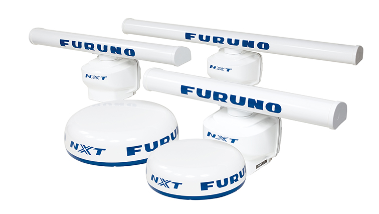
NXT Solid-State Doppler Radar: The Foundation
The NXT series is built around solid-state transmitter technology, which differs from traditional magnetron-based radar in several meaningful ways. Solid-state units produce consistent, controlled pulses that allow for more precise signal processing, particularly at close range — an area where conventional radar often struggles. The NXT lineup spans 25-watt, 100-watt, and 200-watt output configurations, available in 19″ or 24″ radome housings as well as 3.5′, 4′, and 6′ open array antennas, making the system scalable across vessel types from day cruisers to larger offshore boats.
Doppler processing is central to what distinguishes the NXT from conventional radar. Rather than simply painting a picture of surrounding targets, Doppler technology measures the relative velocity of each return. This underlies the Target Analyzer™ function, which color-codes targets in real time: green for stationary objects or vessels moving away, red for anything closing on the user’s position. Fast Target Tracking builds on this by displaying a speed and course vector within seconds of acquiring a target, either automatically via Doppler processing or with a simple tap on the display.
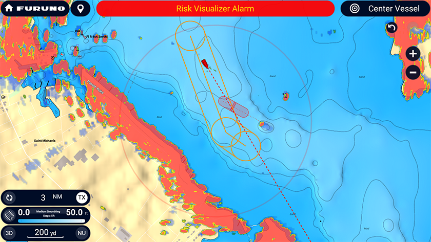
Risk Visualizer™: A 360-Degree Collision Picture
Risk Visualizer™ is one of the more significant additions to the TZtouchXL & TZtouchE platforms’ radar capability. The feature analyzes the current position and movement data of all surrounding vessel targets and generates a real-time visual representation of potential collision zones. Rather than requiring the operator to mentally calculate CPA (closest point of approach) for multiple targets simultaneously, which can be a mind-bending task in busy traffic, Risk Visualizer™ presents that information as dynamic icons on the display, highlighting the targets with the highest probability of conflict.
The system sweeps around the vessel, providing a continuous, at-a-glance picture of risk exposure. For boaters contending with ferry traffic, commercial shipping lanes, or crowded anchorages, this kind of consolidated situational awareness has practical value that goes well beyond traditional radar operation.
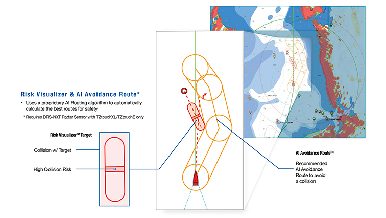
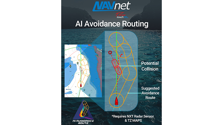
AI Avoidance Route™: From Awareness to Action
Building directly on the data generated by Risk Visualizer™, AI Avoidance Route™ takes the next logical step: when a potential collision is identified, the system intelligently calculates and draws a suggested avoidance route on the chart display. The route accounts for the positions and trajectories of surrounding traffic and presents a clear course correction the operator can choose to follow.
One of the more practical design decisions in this feature is its automatic cleanup behavior. Once the vessel has cleared the hazard, the AI Avoidance Route disappears from the display without requiring the operator to dismiss it manually. This keeps the chart screen uncluttered and reduces cognitive load during a period when attention should remain on the water.
It is worth noting that AI Avoidance Route™ is intended as a navigational aid, not an autopilot function. The suggested route requires the operator to evaluate and act on the recommendation, the system informs the decision, it does not execute it. This design philosophy keeps the captain in the command loop while reducing the analytical burden of collision avoidance.
Integration with NavNet TZtouchXL & TZtouchE
Both Risk Visualizer™ and AI Avoidance Route™ operate within the NavNet TZtouchXL/TZtouchE ecosystem, which offers eight display sizes ranging from a 9” All-glass Multi Function Display (MFD), 10″ or 13” hybrid-control unit, all the way to a 24″ full-touch LCD, along with a black box option for pairing with a captain’s choice of monitor. The radar features are accessible through the MFDs easy-to-use interface and can be displayed alongside chart plotting, AIS overlays, and fish finding data on a single or split screen.
A Practical Safety Layer for Canadian Waters
Canadian boating conditions present a varied set of navigation challenges like tidal rapids, commercial traffic sharing recreational corridors, extended passages in reduced visibility, and seasonal fog along both coasts. Features like Risk Visualizer™ and AI Avoidance Route™ are designed with these real-world conditions in mind, offering an additional layer of decision support that works in the background and activates when it matters.
For boaters evaluating radar upgrades or new electronics builds, the NXT Solid-State Doppler Radar with NavNet TZtouchXL or TZtouchE represents an approach to onboard safety that combines proven radar performance with amazing software-driven intelligence.
For more information, visit: www.FurunoUSA.com