North America’s Great Lakes – Where’s the Water Going?
Lots of Stakeholders in Lake Water Levels
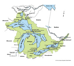
In recent years low water levels on the Great Lakes have boaters and waterfront property owners looking for answers. North America’s Great Lakes hold about 18% of all the surface fresh water on earth and the Great Lakes Basin is home to some 40 million people. From these facts you can be certain of two things: 1) What happens to the lakes is incredibly important and 2) figuring out exactly what is happening to them is incredibly complicated. The 774,000 square kilometers of the Great Lakes Basin includes parts of eight US states and Canada’s largest province, ensuring that lots of different governments, agencies, and interest groups, all want to have their say.
In geological terms, the Great Lakes are relative newcomers, having been around in their modern form since the end of the last ice age, about 10,000 years ago. While near historic low water levels are alarming, it is important to keep things in perspective. We know from both historical and geographic evidence that water levels on the Great Lakes rise and fall all the time and for a wide variety of reasons. Sometimes the variation is much greater than what has been seen in recent times. Some 8000 years ago, during a very dry period, the lakes were about 200 feet lower and the major rivers flowing to the sea were dry.
The basic factors that affect water levels are obvious. Water enters the lakes from precipitation throughout the Great Lakes Basin and leaves through evaporation, consumption, diversion, and the St. Lawrence River. As is always the case, the devil is in the details. Longer term climate changes and even the rebounding of the earth’s surface after the ice ages all have an effect. Various parts of the lakes experienced low water levels in the late 1920s, the mid-1930s, and the mid-1960s. High levels occurred in the 1970s and extremely high levels in the late 1980s, followed by continuing high levels during the 1990s. It is possible that the relatively high water levels over the last 30 years have given many people the impression that these are the norm. The cyclical nature of water levels also makes it hard to discern the longer term patterns and what is causing the changes.
So Who’s in Charge?
In 1909, The US and Canada (actually Britain on our behalf) signed what may be the oldest environmental treaty in the world. The” Boundary Water Treaty” established the International Joint Commission (IJC) to prevent and hopefully resolve any disputes over water use along the border. The commission is responsible to approve any project that could affect water levels. It is this power that lead to the creation of the International St. Lawrence River Board of Control to manage outflows through the St. Lawrence Seaway system and through dams and power plants on the river.
The IJC manages outflow at various points in the lake system. The outflow from Lake Superior is controlled at the St. Mary’s River hydro dam and navigation canals. Lakes Michigan and Huron are basically one lake and their outflow is affected, but not controlled, by the St. Clair and Detroit rivers. Dredging of these rivers has had some effect on Huron and Michigan lake levels, but just how much is a controversial issue. It is believed by some that dredging on the river has lead to scouring of the river bottom thereby increasing the outflow of the lakes. This is the view taken by an advocacy group for property owners on Georgian Bay, however a recent study commissioned by the IJC has recommended that no action be taken regarding the St. Clair River. (See sidebar.) Lake Erie is controlled by the Niagara River power dam and the Welland Canal and finally the outflow of Lake Ontario is controlled by locks and dams on the St. Lawrence Seaway.
The International St. Lawrence River Board of Control held a public teleconference on March 16th where various stakeholders were invited to have their input for the coming season. Listening to the questions from property owners and boaters in the Thousand Islands region, it was easy to understand how the issue of water levels can be contentious. Where one group would like to see more allowance for natural variation, recreational boaters and waterfront property owners want stable water levels through the boating season. The board is a child of international agreements and has as its primary task the proper flow of water through the Seaway. Water levels at the port of Montreal are a primary concern. One caller, who pointed out the negative affect of international shipping to the lakes in the form of invasive species, asked if this might be stopped at some point in the future. While the person chairing the meeting merely pointed out that this issue was not under the board’s control, he could have been forgiven i
f he’d said “not bloody likely”. The vast sums of money spent on the Seaway for the express purpose of allowing ocean-going ships to access the Great Lake means that we can be certain no change is coming in this regard.
In the Short Term
For boat owners and waterfront property owners, it is not always easy to take the long view when seasonal variations, from erosion during high water to accidental grounding during low water, are affecting their pocket books. Although there are no tides on the lakes, the water level can experience rapid changes due to surge caused by strong or prolonged wind. All the lakes have this phenomenon but it is most pronounced in Lake Erie, the shallowest, where water levels at its eastern end have increased by as much a two meters in just a few hours. Once the wind abates the sloshing effect of the water moving back and forth (think of a bathtub), it is known as a seiche (pronounced “saysh). In winter, ice jams can also cause rapid changes and, if accompanied by high water, can cause considerable damage. In the early 19th century an ice jam on the Niagara River effectively dried the Falls for over a day.
Long Term
The issue of water diversion is a mixed bag. The water level on Lake Superior is augmented by diversions for hydro projects of rivers which originally flowed into James Bay. On the other hand the water diverted into the Mississippi river system through the Chicago Sanitary Canal has a negative affect on Lakes Michigan and Huron. With all the talk of the negative environmental effects of low water levels you’d think that the idea of diverting even more water from the Great Lake would be a non-starter. However rapid population growth in the dry regions of the US may also put pressure on the Great Lakes as plans to divert water are put forward. For the time being current legislation prohibits diversion out of the Great Lakes Basin. The results from human intervention so far should be enough to show that any large scale diversion could have disastrous effects and is something that Canada could be expected to vigorously oppose.
Climate Change
This is the big unknown, however, since we do know that water levels are affected by seasonal changes in precipitation and temperature, it stands to reason that long term changes to the weather will have a profound effect on the Great Lakes. Exactly what those effects will be is the subject of much debate. Although some projections indicate an increase in precipitation, this would be negated by an increase in evaporation due to higher temperatures. The more extreme scenarios speak of a drop of up to 8 feet by the end of the century, but a decline of less than half that amount could have a disastrous effect on wetlands, shipping, and boating, to say nothing of waterfront property values. The climate has been changing ever since the origin of the lakes at the end of the last ice age and if, as many believe, we are in for rapid changes in the near future, then we can be sure the lakes will feel the effect. Whether or not you believe the worst case scenarios, or even doubt climate change is real, what we do know
for certain is, with all the pressures of climate and population, careful stewardship of the lakes is more important now than it has ever been.
www.ijc.org
www.greatlakesdirectory.org
www.great-lakes.net
By Glen Cairns
Stakeholders Delivered a Clear Message to the International Joint Commission
Boaters, cottagers, marina owners, engineers and environmentalists were among those who delivered a clear message to the International Joint Commission in Midland in March.
Commissioners from the IJC were on hand to receive comments on a report by the International Upper Great Lakes Study Board. The Study Board focused on changes to the carrying capacity of the St. Clair River since 1962, examining factors such as sediment and erosion, scouring, glacial isostatic adjustment (the rise and fall of the earth’s crust following the ice age) and climate. It concluded that 70 per cent of the decline in water levels could be attributed to climatic factors such as precipitation, evaporation and runoff.
Apparently the Study Board found no evidence of erosion in the St. Clair River, at least since 2000 and in essence the report states although water levels in Lake Michigan and Lake Huron have declined in recent years, no remedial action is required.
That ‘do nothing’ attitude frustrated many who have repeatedly made their views known at previous IJC sessions. Although ideas differ on what type of water level controls should be constructed all agree measures need to be immediately implemented.
Mary Muter has monitored the water quality of Georgian Bay since the early 1990s and serves as the Georgian Baykeeper for Georgian Bay Forever, an advocacy group dedicated to protecting the bay’s unique aquatic environment. Muter said, “The commissioners have heard this before. It’s frustrating. When are they going to start to act? People are fed up saying the same things over and over again. In a perfect world they [the commissioners] would tell the Study Board to go back to the St. Clair River work and try remediation measures. The time to act is now.”
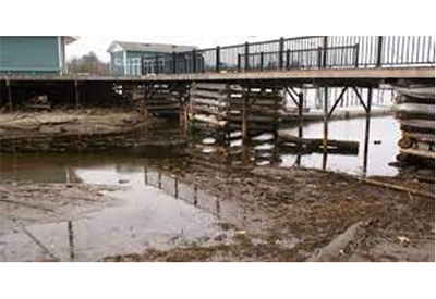
Brian Ramler agrees, calling it the ‘verge of a crisis’. Despite dredging twice in recent years Ramler is looking at lower than ever water at his Twin Bridge Marina in Waubaushene and his marina now has just 20 usable docks, down from his original 50. “Last year I said I needed two more feet of water to function properly, this year I need three feet more of water.”
Joe Hayward traveled from Craigleith to tell the IJC about phragmites, an invasive reed that grows to an astounding 12 feet or more, colonizing and obliterating the newly exposed shoreline.
Cottager Patsy Cross described how their water-access-only family cottage will soon be cut off completely as low levels in the channels dip further. “Soon our cottage will be worth nothing. You’re playing with people’s lives.”
After a lifetime spent on the bay and in business Ramler stated, “I don’t know if they realize how greatly it would affect our way of life here. Once it’s gone, it’s gone. We need to keep the water here longer. We have the chance to regulate the outflow.” He told the commissioners, “You have the power to make that happen.”
By Jennifer Harker