Learning from High Water Impacts on Lake Ontario and the St. Lawrence River
Oct 22, 2020
The International Joint Commission (IJC) is reviewing Plan 2014 and could use your help. The plan spells out how much water is released from Lake Ontario through the St. Lawrence River. A 2020 questionnaire is now available for people to provide information on the impacts of high water levels.
To design Plan 2014, experts in many different fields worked together for years in open public processes. Different plans were tested with computer models of water levels and impacts. The governments of Canada and the United States agreed with the IJC’s analysis and recommendations before the plan went into effect in 2017.
The IJC and both governments also agreed to monitor how different water levels affect shoreline communities, economic interests and the environment. If these real-world impacts were not consistent with what models projected, the IJC would then improve the models to reflect new data on what occurred. This is an example of what is known as adaptive management.
Monitoring Outcomes, Making Adjustments
A binational Great Lakes and St. Lawrence River Adaptive Management Committee (GLAM) was created in 2015 to guide the adaptive management process.
If improved computer models suggest better ways to regulate lake levels, the GLAM Committee presents the evidence and new ideas to the Lake Ontario-St. Lawrence River Board, which oversees the operation of the regulation plan, and they decide what to recommend to the IJC.
The governments set a 15-year window for this review, but record high water levels on Lake Ontario in 2017 and 2019 caused substantial shoreline damage, spurring governments to fund an expedited review process for Plan 2014, which started in February 2020.
The expedited review began by collecting information to help the Lake Ontario-St. Lawrence River Board make decisions when it has authority to deviate from the plan under extreme high-water conditions (see “Sidebar: Regulation Doesn’t Prevent Flooding” at the end of this article).
Early this year, information from the review supported a decision to delay the start of navigation in the Montreal-Lake Ontario portion of the St. Lawrence Seaway. This enabled the board to sustain higher outflows that lowered Lake Ontario by an additional 3.5 centimeters (1.4 inches).
Currently, the GLAM Committee’s expedited review is gathering information on the socio-economic and environmental impacts experienced along shorelines of Lake Ontario and the St. Lawrence River, particularly in 2017 and 2019, along with impacts to other interests such as Seaway navigation.
The initial data will help GLAM members inform the board and IJC on how the regulation of Lake Ontario water outflows during extreme conditions affects shoreline properties and community investments upstream and downstream of the Moses-Saunders Power Dam.
This information can help the board with deviation decisions as early as spring 2021 if Lake Ontario and the St. Lawrence River are again faced with high water levels. After 2021, the expedited review will provide a comprehensive assessment of Plan 2014 under the full range of water supply conditions. 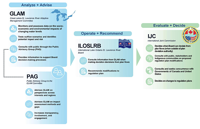
Engaging Stakeholders
In 2020, the IJC appointed a Public Advisory Group (PAG) to help the GLAM Committee review Plan 2014.
The PAG members are knowledgeable and committed, some have been critical of the IJC, and the group represents different and sometimes conflicting interests from the Great Lakes system.
PAG members have access to the same information as the GLAM Committee, but provide what GLAM does not have: the perspective of people directly affected by water levels in various ways.
In creating the GLAM Committee, the IJC recognized the importance of being flexible as the regulation plans are implemented and took the step to challenge and monitor its decisions to see if it’s possible to do better over time.
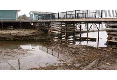
We’d like to hear from you. Please take a few minutes to share your observations, experiences and photos about the impacts of high water levels by filling out the questionnaire.
Sidebar: Regulation Doesn’t Prevent Flooding
Water levels and flows in Lake Ontario and the St. Lawrence River affect a range of interests, including shoreline property and infrastructure, recreational boating and tourism, commercial navigation, hydropower production and the ecosystem. Any plan for regulating Lake Ontario outflows attempts to set outflows in a way that fairly balances the effects on these interests.
When inflows to the lake and river are extraordinarily high because of extreme weather conditions and the resulting increased water supply, as they were in 2017 and 2019, flooding and other coastal impacts cannot be avoided by any plan for regulating outflow. So, while regulation of Lake Ontario outflows has reduced flood peaks and moderated the effects of extreme water supplies, one must remember that flooding on the Great Lakes is caused by natural conditions that for the most part cannot be predicted or controlled.
When extreme conditions occur, the IJC’s Lake Ontario-St. Lawrence River Board has the authority to deviate from the rules of Plan 2014 to increase or decrease outflows.
The board’s priority then is to provide all possible relief to shoreline communities upstream and downstream of control works in the St. Lawrence River. Members also must consider that high flows can affect navigation safety and the formation of ice jams in the river, and how these risks compare to the amount of relief that can be provided to shoreline communities.
These are difficult decisions that must be made without knowing whether storms will roll across different parts of the basin or how other uncertainties may play out. The GLAM Committee is working to ensure that the board has the best possible information on how different water levels and flow rates can affect shoreline communities and other interests.
Note – this is a reprint of an article that ran in the October issue of the IJC’s Great Lakes Connection
