The Art of (Paper) Charts
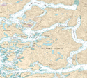
 They decorate cottage walls, get lacquered into table tops, may have coffee stains, probably have water stains, are definitely creased, sometimes rolled and always informative. They are usually only printed with a few colours of ink, mostly one sided, regularly cover about 12 sq. ft. and are chock-a-block full of details for navigation and often inscribed with an ‘X’ that marks the spot.
I speak of paper charts. To some, a substantial quantitative presentation of data, facts and geography essential for safe passage from port to port; to others, a work of art that happens to be useful for navigation. Taken with a pencil, eraser, dividers and parallel rules, plus some simple math and a wee bit of knowledge, you too can navigate the seven seas!
Here is some intriguing information concerning charts that might help you find your way from one port to another, or provide topics for nautical discussion while at anchor in a sheltered bay with friends aboard.
Latitude and Longitude
Those parallel and perpendicular lines are the human invention by Flemish cartography Gerardus Mercator who, in 1569, tried to bring order to the roundness of the globe in transferring it to the flatness of a chart. It is not perfect with growing inaccuracies as you near the poles, but it has seemed to work well for close to half a millennium.
Lines of Longitude or meridians circle the globe north to south, each one the same size as the other as they all pass through the north and south poles. Interestingly, by running north and south they measure degrees and minutes of arc east and west from the Prime Meridian (0°) which passes through Greenwich, England – and obviously other towns and villages coincidentally located on that line. (Note: Only in the late 1880s did everyone finally agree to use Greenwich except, go figure, France who continued to use a meridian that ran through Paris, a few degrees to the east, for several decades – but I digress.)
Lines of latitude or parallels run around the globe east to west and their circumference gets smaller as they go north and south from the widest part of the earth, the equator, that being the 0° line of latitude. These parallels measure distance north and south in degrees and minutes.
One of the most important details about these lines and measurements for chart work is the saying, “a mile a minute.” On the right or left side of a chart are units of latitude in degrees and minutes and one minute of latitude equals one nautical mile – period. But, always use your dividers to measure the latitude scale nearest your position on the chart due to Mr. Mercator’s’ projection which sees the physical length of a minute of latitude change from the lower part of the chart to the upper part. (Note: To those downunder or planning to cruise there, it’s the other way around, upper to lower.)
The Compass Rose
Is there a prettier term or a more beautiful diagram with such potency? Well, maybe I have gone overboard with such flowery language, but let’s see what this diagram offers us. We know, although we may not fully understand, that the earth has a magnetic polarity that is subtle enough to be able to consistently pull a metal needle floating freely in some medium, to align north-south.
Although the lines on a chart are perfectly North/South and East/West they do not truly reflect the magnetic pull of the poles. What this means is that a compass on a boat will point north but it is the magnetic north not the true north – and that magnetic north direction is a little different from place to place and changes gradually year to year. So back to the chart and the compass rose, we see that the True bearings are North/South, but the Magnetic ones are usually off a bit to the east or west. Cartographers are pretty bright people and not only do they know the variation between True and Magnetic for each chart, but the amount that the variation changes each year. In any calculations that you do or courses you set, you must include the variation and convert between True and Magnetic headings – AND – know the age of your chart since the variation displayed in the compass rose is for the year that the chart was printed.
If the chart is five years old, you will have to add or subtract the annual variation change that is displayed there to ensure your plotted or steered course headings and bearings are accurate.
With this knowledge, it is now up to good manipulation of the parallel rules to line up a bearing from the compass rose and translate it from a course heading – or vice versa.
Water Depth
One of the most important things that charts do is tell us how deep the water is. Whether you think it is more important to know where the deep water is, or where the shallow water is, depends on your perspective about that well known glass of water; half full or half empty.
Depth has traditionally been measured in feet and fathoms, a fathom being 6 feet, but more and more we are seeing metric charts where depth is measured in metres. It is not a Canadian initiative but rather one supported by the International Hydrographic Organization (IHO) based in Monaco of which Canada is a member. So, just like our Canadian ability to convert Celsius from Fahrenheit, miles to kilometers and pounds to grams, be prepared to shift your nautical mindset from feet and fathoms to metres and your depth sounder display as well – depending on each chart you use.
Chart Symbols
Depth indications alone do give us a good idea where we can navigate and where we can’t, but charts are peppered with symbols of fixed and floating aids as well as landmarks, wrecks, underwater cables, and even artillery ranges. One of the worst things that can be done on a chart is to plot a course by “connecting the dots”, drawing course lines from one buoy to another regardless of other information provided on the chart. There are currents, shoals, those artillery range ‘no go’ zones, busy commercial shipping lanes, submerged obstructions and fish havens. The Canadian Hydrographic Service Chart No. 1 is an integral tool for chart work and even though it is called Chart No. 1, it’s a book, entitled Symbols, Abbreviations and Terms Used on Nautical Charts. Reading and applying this book gains you membership into the esoteric society of chart readers since gleaning all the information a chart can offer you is a secret few have unraveled. But also keep an ear to Coast Guard radio stations as they broadcast (and print out) Notice to Mariners (NotMars) that inform mariners of new buoys, changed buoys and out of service buoys.
This brief review of the hydrographic chart should motivate you to take a closer look at the charts you use and think twice about plotting courses, reading bearings off compasses, noting depths, recognizing buoys and correcting the variation based on the age of your chart.
Indeed, there’s an ‘X’ that marks the spot on every chart and with a pencil, an eraser, dividers, parallel rules and a bit of knowledge, you’ll find a treasure chest of information right in front of your eyes.
NOTE: The Canadian Power and Sail Squadrons, (CPS) cover chart reading in detail in their very popular, introductory level “The Boating Course”.