The Great Loop – Part I
By Lynn Lortie
Photos by Lynn Lortie
The much anticipated envelope arrived in the mail at the beginning of September 2010. It was sent from the AGLCA, the America’s Great Loop Cruisers’ Association. Inside the envelope was a letter from the association congratulating us on completing the Loop, a gold AGLCA flag that we could proudly fly on our signal pennant and a certificate, our “Baccalooperat” This piece of parchment meant as much to us as receiving a degree from a university. We had done it. We had conquered the continuous waterway that took us through the Great Lakes, the inland rivers of the United States and the Gulf and Atlantic Intracoastal Waterways.
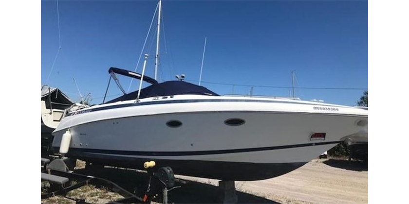
Pat and I chose to start our Loop from our home port of Midland Ontario, in southern Georgian Bay. We left port on August 3 2008 aboard our home built 38’ sailboat Adamant 1. We sailed across Georgian Bay, and entered the North Channel, the body of water that lies north of Manitoulin Island and south of the La Cloche mountains. These waters are our summer playground, the greatest fresh water cruising area on earth. There we met up with many of our friends and had some terrific farewell dinners. From the South Benjamin Islands we headed west and entered the US at Drummond Island.
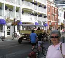
 One of the greatest things we did was to leave early enough to have time to spend in Lake Michigan. We spent a day touring Mackinaw Island, an amazing island to visit. There are no motorized vehicles allowed on the island, only bicycles and horse drawn carriages. From there we ventured down the eastern shore of Lake Michigan and headed into Charlevoix, Leland, Muskegon and Holland. The scenery along the easter shorline of the lake is magnificent and the anchorages are so welcoming. An overnight sail from Holland brought us into Chicago by lunch, the day after Labor Day. I had expected that wonderful early morning photo opportunity where we would see Chicago lit up by the morning sun. It wasn’t to be. There was fog and it didn’t lift until we were two miles from the entrance lighthouse. So much for the photo of the week!
We spent the next five days touring Chicago and getting the mast down. Our friends Kent and Linda Charters joined us there to do the first part of the river with us. On Monday September 8th, we passed through the first lock into Chicago. This route takes you through the downtown section of the windy city in between all of the magnificent towers. Chicago is 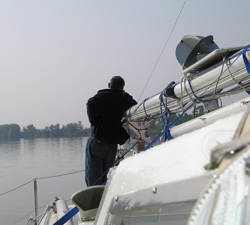 known for its fabulous architecture and it doesn’t let you down. The trip through the city is worth every minute. You get to see some of the finest buildings in the world from a unique perspective. There is another way to get to the Illinois River, and that is the Cal-Sag. This route is favored by large cruisers and trawlers that won’t clear the 17’ bridges downtown.
After you have cleared the high rises, you then encounter the industrial section of the city. This is decidedly the smelliest few miles you will ever endure. The water is dirty and there are also odors you would not want to have prolonged exposure to! This is also where you start to meet the tows. We aren’t sure why they call them tows, as they are actually pushed. There can be as many as 20 huge barges tied together, 4 wide and 5 deep, all pushed by a huge tug. Each barge carries the equivalent of 47 tractor trailers. They carry everything from gas, coal, scrap metal, wheat, and sawdust, just to mention a few. They are massive and command your respect. When you meet one, it is proper to call the captain on channel 13 and request instructions from him on which side to pass. He will then tell you he will “meet you on the one whistle” which is pass port to 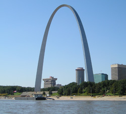 port, or “meet you on the two whistle”, which is starboard to starboard. He determines that based on what he is doing with the tow and which will be the safest side for you to pass on. It is best to memorize those two phrases immediately, as the consequences of doing it wrong could be your undoing! I wrote the phrases down on a small piece of cardboard that stayed on the binnacle in front of the helmsman for the entire trip.
That being said, the first test is to be able to understand what the captain of the tow is saying. From our experience, most of them speak like they have marbles in their mouths and they all have very deep southern accents. It’s best to confirm what you heard, or thought you heard. But the captains are also very helpful and considerate. If you are following one, they will radio you, then slow down and let you pass. They will let you know of any tows that are coming your way as well as the status of fog on the river. They are great guys. One captain had a fleet of barges so huge, we could only see the roof of the tug. We asked him how he could see. He replied that he had a parrot on the roof with a microphone! What a comedian. Some days, we met as many as 15 tows, some on 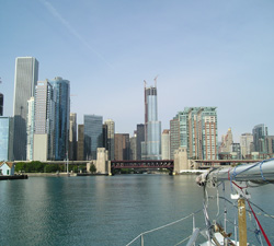 straight stretches and some coming around tight bends. One time we had to squeeze our boat into a small space between two parked barges, while a tow inched by, way too close. Another time while avoiding a large tow, we moved over so close to the embankment that we were pushing tree branches out of the way! But eventually, you get used to them. There’s a note in my journal that reads “tows don’t panic us any more”.
One of the first things you come to realize on the river is that the distance between safe anchorages is quite often further than a sailboat with 5’ draft can go in a day. This is the one thing that troubled us the most. Its fine to plan your day and your next anchorage in advance, but a delay at any lock can throw your schedule out the window. Then you are stuck finding something safe and suitable before dark. It’s always best to have a couple of backup anchorages in the plan. We have tied to lock walls, city seawalls, and have also spent many peaceful nights in secure anchorages behind islands or in creeks.
On September 13th, we were caught in the Illinois flood. It was caused by the excessive rain from hurricanes Gustaf and 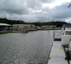 Ike and by a deep low over the Midwest. We were traveling with Rob and Jude aboard their 32’ sailboat. We had both tied up to the municipal dock in Ottawa Illinois, when a fellow from the rescue station next door came over to advise us that the river was expected to rise overnight by 8’. It wasn’t safe for us to stay there. He made some phone calls and was able to get us two docks at Heritage Harbour, a floating marina, three miles upstream. By now it was 9 pm, pouring rain and the river had already risen 3’. The first rule of the river is to never, under any circumstances, run the river at night. But we had no choice. He helped us off the dock and we motored upstream, against 4 knots of current in the dark. We can only imagine what kind of debris floated past us, unseen. We were grateful to get tied up couple of hours later, safely off the rapidly rising river. We stayed tied to that dock as the river rose 18’ in the next few days. We were able to leave 13 days later, but the river was still 9’ over flood stage. It gave us some extra current, which increased our speed, but gave us a ton of debris to dodge. We kept reminding ourselves that we were doing this trip for the adventure.
This river trip is not for the faint of heart. It takes constant attention to detail, watching for tows and debris, and following 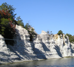 along the charts mile for mile. You need to know where you are at all times in case you have to contact a tow for instructions. It is very easy to lose your place on the chart if you don’t pay attention. Traveling with another boat, we were able to take turns being the lead boat. It relieved some of the pressure because every other day we could just follow and relax a bit. The Illinois River, once past Chicago, becomes peaceful and pastoral. Even though it was still flooded, it was beautiful. There are few towns, and even fewer marinas that were accessible to us. Most marinas that we did stay at had courtesy vans that we were able to use to go into town to shop. Adamant 1 has a large fridge and freezer, so were able to keep stocked up and the constant motoring kept the batteries topped up. We can carry 75 gallons of diesel and 200 gallons of water, so we can go a long way before we need to stop at a dock.
When we hit the Mississippi River, we hit it running. We had currents of up to 4 to 5 knots which helped boost our normal hull speed up to 10 and sometimes 11 knots! The Mississippi River is also where we began to encounter turbulence. At 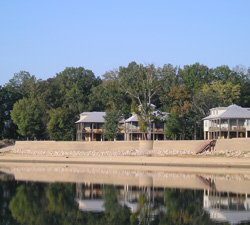 the mouth of the Missouri River, where it meets the Mississippi, the water churns, making the water too fast and too rough to traverse. The Corps of Engineers has put in a canal bypassing that section of the river. Once you go through the canal, just at St. Louis, the Mississippi River comes barreling back down on you. We watched the sailboat ahead of us in the swirling water going as fast sideways as it was forward. It felt like we were white water rafting in a 38’ boat! Luckily it only lasted a short time before the water smoothed out again.
St. Louis is a very busy area and is barge heaven. There was almost 20 miles of barges and tows, either parked along the shoreline, sometimes 8 deep, or anchored in the river. It was fascinating to see the city from the river, the huge arch, the high rises, and the casino boats. There wasn’t anywhere we could stop so we could tour the city, no municipal dock or marina. The Mississippi River is also where we found it the hardest to find anchorages. When we did get to an anchorage, we had to account for the 4 knot current when entering or exiting. It made for some exciting moments. And there was more turbulence to be found along the way, for where the river made a tight turn, the current flowed faster.
 We’re back to the adventure theory. But the anchorages were quiet and still. There was also plenty of wildlife to see. There were white herons, bald eagles, white pelicans and occasionally deer and wild boar at the water’s edge. At night, in the quiet, we could hear the crickets and frogs and once in a while the howl of a distant coyote.
Along the shores of the Mississippi there are wing dams underwater. The wing dams control the flow of the water helping to prevent silting in. When the extra current meets with a wing dam on a tight turn you get a boiling water effect that will fling the boat sideways. It happened to the boat ahead of us, and then almost immediately, it happened to us. I was on the wheel when a huge whirlpool opened ahead of us.It looked like a giant drain ringed with white foam. Before I could turn the wheel, it flung our 20,000 lb boat sideways, scaring the daylights out of me. It was only seconds, but we got out of it really looking forward to the other two spots we had been warned about! We are back to the adventure theory again! But the scenery and the peacefulness of the river will relax you. Every turn gives you something new. I had expected to see more homes 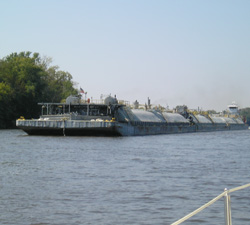 and towns along the river, but when the river can rise 18’ in a few days, it’s not surprising that everything is built well back from the shoreline, behind the levees. We spent 4 days on the Mississippi and though it was trying at times, it was picturesque.
At Cairo Illinois, we turned up the Ohio River. The river is much wider and a lot cleaner than the Mississippi. There are sand beaches that go on forever and we felt like we were back in cottage country. It was a short crossing for us, only 60 miles to the Cumberland River. In the middle of the area is the town of Metropolis, home town to Superman. We also came across a town that was home to Popeye. Who knew!
Along the rivers, there are many, many locks. Some were small 28’ drops, some were 1500’ long or 40’ drops. We had no problems navigating through them at all. There are also wicket dams…think retractable dams. When the water is high, the doors are lowered to lie flat on the bottom, and boats pass over top of them. We went over a few with no hesitation or drop in speed.
When we got to the Cumberland River, just past the magnificent sand dunes lining the shores of the Ohio River, we headed down the 30 mile canal, and ended up in Barkley Lake. This is a huge tourist area that takes up a good part of Kentucky. We spent 3 days in a marina there, shopping, doing laundry and boat chores, and touring Paducah, a must see town. We then went through the 1-1/2 mile canal that links Barkley Lake to Kentucky Lake. The lake is huge. We now encountered local people out sailing and fishing. It’s an area I could live in. The east shore is all state owned, no developments, all pristine wilderness. The water was clean and warm enough for swimming. One could spend the whole summer there and never tire of the surroundings. The western shore is dotted with cottages, huge homes, and plenty of marinas that are accessible to all, a nice change from the previous rivers. There are islands to anchor behind, and places to explore by dinghy. The trip through the Kentucky Lakes is followed by the Tennessee River into Pickwick Lake. These two areas were worth everything we had to go through to get there. If we thought the Kentucky Lakes fantastic, then the Tennessee River and Pickwick Lake took our breath away. The weather remained hot and sunny, and we slowed down to explore and enjoy the area. Now we were seeing lots of homes and communities along the shoreline. There were quite a few marinas, all within a normal days run for a sailboat. At anchor, we seldom shared the anchorage with more than a couple of other boats. We toured Shiloh National Military Park, where a famous battle took place in April 1862. In two days of fighting, 23,000 men lost their lives. There are tons of monuments, plaques, and cannons on display. It was a memorable area to visit.
We left the Pickwick Lake area and entered the Tennessee-Tombigbee Waterway, known to all as The Tenn-Tom. It is a man made canal that stretches 253 miles from Pickwick Lake in the north, to Demopolis in the south. Originally proposed back in the late 1700’s by the French as a way of connecting the Tennessee River and the Tombigbee River, work on the canal did not start until December of 1972. It was dedicated on June 1, 1985. The cost to build the waterway was nearly 2 billion dollars. This mammoth undertaking moved more earth than was moved to create the Panama Canal. The river was straightened in some places with manmade cuts, was dredged where the water was too shallow, and locks and dams were added. There are ten locks to go through on this canal, the highest being the Jamie Whitten Lock which has an 84’ drop. There are towns and marinas along the canal, and while we had been apprehensive about transiting such a narrow waterway, it was one of the more relaxing parts of the trip. We saw few tows, and the lock operators would call ahead to the next lock and it would be open and ready for us to transit when we arrived. The lock operators, tow captains, and staff at marinas were all terrific. They went out of their way at every occasion to help us and make our stay in their backyards as pleasant as possible.
We left the Tenn-Tom and entered the Black Warrior River. We were now only 216 miles from Mobile. This area was very remote and very much in its natural form. It has been left to take its own course without help from the Corps of Engineers. The river is much wider and the vegetation grows right down to the river edge. In some areas, there are white sand beaches that make you want to stop, grab a blanket, and lie in the sun. The only drawback to that is the alligators have gotten there first. We saw many of the huge reptiles sunning themselves along the shore. That’s when you realize that you are no longer at the top of the food chain. A late afternoon dip is now out of the question. There are no marinas on this river, but there are good anchorages. Some are small creeks or rivers, others are bridge abutments, or indents along the shoreline. We stayed in all of the above without any problems, just noisy trains the night when we chose a railroad bridge abutment! The fog on some mornings delayed our departure. You would not even consider running the river in fog any more than you would run it at night. The fog was very thick, but as soon as the sun rose high enough to shine down into the river, it went away. This area is also where we encountered many switchbacks and sharp bends in the river. We always put out a security call that we had entered the switchback, with the hope that if there was a tow in there, he would tell us and we could be prepared for him, or wait for him to exit before we went in. Our next trip we will invest in AIS, Automatic Identification System, which will alert us on our GPS to any oncoming tows. We were lucky in that we never met any oncoming traffic.
On November 1st, we entered Mobile Harbour. What an amazing area. It is the largest deep water port on the Gulf and the size and variety of ships was staggering. There were tows of every description, a cruise ship in dry dock, and a new “stealth” high speed navy warship still under construction. Our heads should have been on swivels. I ran back and forth across the cockpit taking picture after picture. It was hard to believe we had made it to the end of the river system.
We took a dock at a marina in the Dog River and hauled out to repaint the bottom and do some minor repairs. We had the boat launched and put the mast up. We were a sailboat again! On November 10th, we headed out into Mobile Bay, following an oceangoing cargo ship. The water was crystal clear and salty! That first day was when we spotted our first dolphins coming up to the bow of the boat. I was so excited, Pat was afraid I’d fall overboard. They accompanied us right to Pensacola where we entered the Gulf of Mexico. We opened a bottle of champagne, poured some over the side for Neptune and headed south. We were on to the next leg of our Looper journey!
Photo Captions
Photo 1 – Mackinaw Island was a must visit. No motorized vehicles are allowed on the island whatsoever.
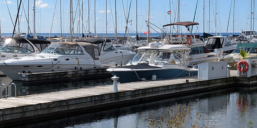
Photo 2 – All the marinas in Lake Michigan were well protected and very accommodating to transients.
Photo 3 – Pat and I would take turns on the bow watching for debris in the river after the flood
Photo 4 – The Arch in St. Louis was impressive but could not be reached by water. There wasn’t any sort of marina or town dock in St. Louis to stop.
Photo 5 – Entering downtown Chicago after clearing the entry lock
Photo 6 – During the flood in Illinois we had to use our dinghy to get from the dock to the shore.
Photo 7 – The White Cliffs of Eppes were spectacular and went on for miles
Photo 8 – Houses along the river were built on stilts because of the frequent flooding. That still didn’t stop some from being flooded anyway in September
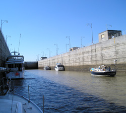
Photo 9 – Some of the locks along the river were huge to allow room for the massive tows
Photo 10 – Meeting a fuel oil tow along the river