Toronto Waterfront update
Feb 11, 2021
The Toronto waterfront is changing for several reasons including esthetics, flood mitigation. It’s about time – between the downtown area and Ashbridges Bay has been something of an abandoned wasteland. Several dinghy clubs including the legendary Water Rats and the Toronto Multihull Club have been “squatting” for decades (since the early70s or even before!) and have developed a sailing culture in the midst of rubble.

Before: looking south along the Don Roadway (Right)

After: Looking south from the east side of the rebuilt Don Roadway (Left)
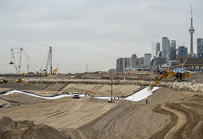
The Port Lands Flood Protection Project is about taking action to protect Toronto’s southeastern downtown area. Right now, in an extreme weather event, floodwaters from the Don River would overwhelm portions of the Port Lands, South Riverdale and Leslieville. The plan is to reconnect the Don River to Lake Ontario by creating a naturalized river mouth.
Toronto is finally starting to take advantage of its massive waterfront, with all new trails, bridges, green spaces and an entire neighbourhood on a brand new island in the works.

Before: Industrial desert (Left)

After : View looking south at River Valley Park (Right)
Among the latest plans for making the best of our shoreline is an all-new park that will provide sandy beaches, public art, space for events and some areas for canoe and related boating where today there are warehouses and crumbling roadways.
The nearly two acres of open public space will sit just above Tommy Thompson Park on Leslie south of Commissioners Street, and will offer stunning vistas of the downtown skyline, as well as the entire length of our unique 2.8 km-long ship channel that is still used today.
Work is actually underway and there will be a lot of change over the next years including new bridges and parkland and along the eastern side of Toronto’s inner harbour.