See What You Cannot See
Rob MacLeod
Electronic innovations that allow you to see in the dark, in the fog and in the depths
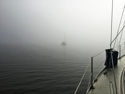
We cruising boaters often go places we have never been. Cruisers and fishing enthusiasts sometimes arrive in the dark, get caught in the fog or find what looks like a good anchorage, but do not have recent chart information or survey data to know if the anchorage is safe. We wander up rivers and into corners of small harbours in search of shelter or to pursue a particular finned prey.
We would all love to be able to pick navigation aids out from a confusing cluster of lights while entering a harbour after dark. And what about areas of shifting shoals and underwater obstructions?
In this issue, we look at several electronic innovations that will help us accomplish just that – improve our ability to see what ‘normally’ we cannot see.
Seeing in the Dark and Fog
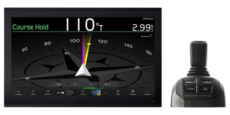
Leading off this parade of innovations is Raymarine’s Cruise Clear [AR] (Augmented Reality). Like many of the innovations in this article, a system is involved, in that it takes more than a single element to achieve the desired results.
The Cruise Clear AR requires 3 components – a Raymarine Axiom® multifunction display (MFD), the AR200 Stabilization Module and a compatible IP camera such as Raymarine’s CAM210 and CAM220 cameras.
The AR200 Stabilization Module provides position, heading, pitch and roll data to compensate for the movement of the boat and camera to provide reliable information for the Augmented Reality display.
What does the augmented reality do to enhance your boating safety and pleasure? AR improves your ability to see navigation aids and marine traffic in the dark or low visibility. The information from the GPS, AIS receiver (if installed) and video camera is combined on the screen of the multifunctional display showing the position and information of what is in front of your boat.
 Figure 3 Components of Raymarines Cruise Clear AR
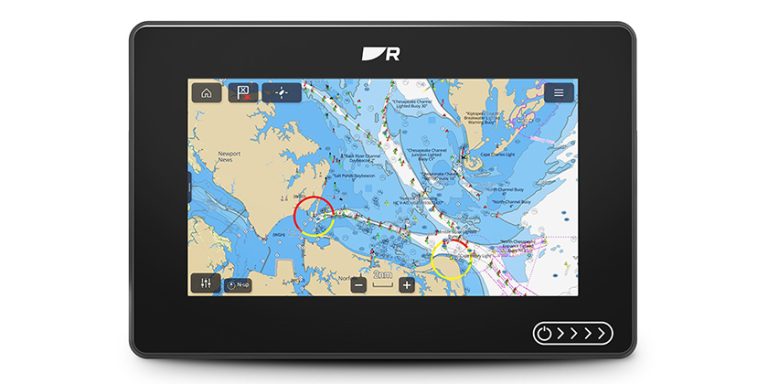
 Figure 4 Navigation Aids and AIS vessels identified
So, what is it you get to see?
• Critical charted navigation aids overlaid on HD video
• Live AIS Targets with colour-coded labels providing instant identification, status, and risk-assessment
• Positive identification of AIS equipped vessels on the horizon
• Major chart objects are identified for instant, heads-up recognition
• ClearCruise AR technology shows saved waypoints
 Figure 2 Components of Raymarines Cruise Clear AR
By the way, Raymarine Axiom users can also use the LightHouse 3.6 OS to fly the DJI Mavic Pro drone. The Axiom UAV (unmanned aerial vehicle) app automates many common tasks including launch, airborne imaging, in-flight navigation, and return-to boat. Fishing and cruising boats alike can greatly benefit from having this added aerial imaging platform integrated onboard. Checkout the demonstration video on Youtube.com (MoJrW6fXgx0).
Seeing in the Depths
There has been great advancement in depth sounding over the past few years. Furuno, Garmin, Simrad and Raymarine have all developed better tools for seeing the depth and quality of the bottom. This is great news for recreational, cruising and fishing boaters.
 Figure 5 Side by Side Digital Chart and Depth Information
From a cruising point of view, having a clear image of an anchorage allows the cruiser to select the best location to ensure a solid hold for the anchor and that leads to a better night’s sleep. In addition, with forward looking sonar, boaters can see hazards under the surface such as deadheads, submerged objects and fast rising bottoms. More on forward looking sonar later.
As a cruising sailor, I have come to rely on my side-by-side display of chart and bottom quality when I am anchoring. I can see the depth contour, actual depth and quality of the bottom – all in real time.
What is CHIRP?
One bit of technology that has improved the quality of depth information is CHIRP technology. Traditional sonars produce a “tone burst” energy pulse. While it is high in power it is short in duration – usually in the 50 or 200 kHz range. Due to this short duration, the sonar tends to limit the range, resolution and what targets can be detected in the water column.
 Figure 6 CHIRP Technology
CHIRP stands for Compressed High-Intensity Radiated Pulse and sends high pulse energy into the water column. It does this to generate images using a full range of frequencies. CHIRP enhances bottom tracking at deeper depths and at a higher speed. That is what makes CHIRP technology of value to coastal cruising as well as fishing.
 Figure 7 AirMar B175 Tilted Installation
Although primarily intended to improve the images of fishing targets, the CHIRP technology is incorporated into depth products from Furuno (TruEcho), Simrad (S5100), Garmin (ClearVu) and Raymarine (DownVision) and provide improved depth information by use a precise sweep pattern of many frequencies (i.e., 28-60 kHz or 130-210 kHz). The longer pulse is required to be able to sweep through all of the frequencies. CHIRP ready transducers, such as AirMar, have bandwidth at high, medium and low frequencies.
Forward Looking Sonar (FLS)
Forward Looking Sonar is intended to enhance the vessel’s safety in uncharted waters and remote areas by scanning and displaying the seabed in front of the vessel. I struggled with how to approach this section from a cruising – rather than that of a fishing – point of view. I turned to one of my go-to sources – Attainable Adventure Cruising (MorgansCloud.com)
“The EchoPilot has made a huge difference to our ability to cruise safely in the high latitudes. It isn’t necessary, however, to go to the high latitudes to get good use from a forward scan sonar: We use it all the time, even in well-charted waters, to guard against the consequences of a navigation mistake and when anchoring it allows us to survey for anchor placement with much greater accuracy and less hesitancy about getting too close to shore.” – Phyllis Nickel and John Harries, EchoPilot Forward Scan Sonar FLSII – January 2005
As John goes on to say, the FLS allows him to cruise up to 6 knots, looking forward 200 meters (600 feet) in deep water. The caveat is that the forward-looking ability is a factor of 3 to 5 times the depth. That means in 15 feet of water, the FLS will reach out only 45 to 75 feet, so it is prudent to reduce speed in shallower water. Harries also points out the need for a down-looking sonar to determine bottom type.
According to their website, EchoPilot (EchoPilot.com) patented the world’s first real time FLS in 1992. In 2012, EchoPilot developed and patented the 3D forward sonar product. EchoPilot was acquired by Danish-based electronics company Daniamant in September 2017. The EchoPilot is offered in FLS Platinum, FLS 2D and FLS 3D.
EchoPilot FLS 3D is a “Black Box” system which enables any Chartplotter, Multifunction Display, or PC with a video input to become a fully functional 2D color Forward Looking Sonar (FLS). The FLS 2D offers all the best features of the EchoPilot forward looking sonar displayed on a full color, 7-inch TFT LCD display.
The FLS 3D comes with twin retractable transducers to ensure complete forward coverage whatever the hull form. The view ahead is 60 degrees in the horizontal plane and over 90 degrees in the vertical plane. The forward range is up to 200 m ahead at 100 meters depth.
 Figure 9 EchoPilot 3d Forward Looking Sonar
Simrad
The ForwardScan transducer operates at 180kHz to reduce interference from traditional 200kHz echosounders and provides forward view of 8 times the current depth. ForwardScan integrates with NSS or NSO evo2 multifunction display to provide real-time 2D imagery.
According to Simrad’s web site, ForwardScan connects quickly and easily to any Simrad NSS evo2 multifunction display via the StructureScan port, with no additional hardware necessary. On NSO evo2 modular systems, or NSS evo2 systems already using StructureScan, ForwardScan may be connected via an optional Simrad SonarHub sounder module.
 Figure 10 Simrad ForwardScan showing Safe (Green), Caution (Yellow) and Danger (Red) settings
Simrad forwardscan https://www.youtube.com/watch?v=a6_X4qH41qI
Garmin
Premium FrontVü Forward-looking Sonar
 According to Garmin’s website, the Panoptix multibeam thru-hull transducer with premium FrontVü forward-looking sonar helps you avoid running aground by displaying the bottom ahead of your boat in real time on your chartplotter. Panoptix FrontVü sonar displays bottom up to 300 feet ahead of the boat (at 8 to 10 times the current depth) and has a narrow beam, forward-looking sonar (20 degrees).
According to Garmin this allows you to focus on the bottom in front of your boat and not be confused with what is off to each side. It also includes an Altitude and Heading Reference System (AHRS) sensor for motion stabilization that allows you to see what is in front of your boat even in rough water conditions. And all the FrontVü forward-looking sonar image data can be easily shared with other chartplotters across the Garmin Marine Network.

Conclusion
Figure 12 Piloting the Great Dismal Swamp
There were times during both of our trips from Lake Ontario to Florida and Bahamas, we could have made great use of Forward-Looking Sonar (FLS) and RayMarine’s Cruise Clear [AR]. From discovering some of the sunken trees through the Great Dismal Swamp to seeking out the shifting bottom in the inlets along the ICW. It is easier to respond to something you see on the screen 80 – 100 meters in front of your vessel than reacting to a suddenly shallowing bottom on an analog or digital standard depth sounder.
CAVEAT – All of the producers of these invaluable navigation tools were clear that at higher speeds and in shallower water, the range and ability to detect hazards diminishes. It is the operator’s responsibility to adjust for conditions and interpret the available information to ensure the safety of the crew and the boat. RM