Peering Atop Islands and Around Bends
The latest in AIS technology, regulations and market offerings across North America
By David Schmidt
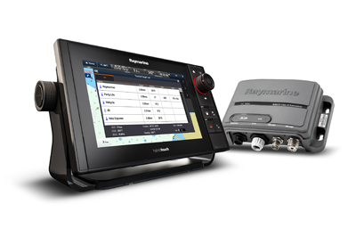
The Furuno FA170 is a stand-alone Class A, IMO approved universal AIS transponder with a clear 4.3 inch colour display. The FA170 outputs AIS data to ECDIS, radar and other navigational equipment for collision avoidance support. It has sufficient output ports for dual configuration of ECDIS and your radar system. It has LAN interface available for efficient network integration into your bridge system. There is also a Bridge Alert Management (BAM) ready feature that meets the specific requirements for alerts and interconnection with bridge alert management as specified in IMO MSC.302 [87]. The FA170 also receives AIS – SART signals for assisting in streamlining search and rescue activities. It is designed to support larger vessels and commercial craft.
www.furuno.com
A thin breeze skittered across the Gulf of Maine, and a low cloud ceiling stamped-outany moonlight, making for a darknight aboard my dad’s J/44, Southern Cross. My wife and I were standing watch with nothing to look at, save a few distant lights. While my wife enjoys excellent vision, I suffer from severe red-green color blindness that makes it hard to determine if I’m looking at bow and stern lights, discreet vessels, or both. Given that in August of 2006 Automatic Identification System (AIS) wasn’t yet widespread amongst recreational craft, we spent the next few minutes trying to discern the nature of the scene before consulting the radar, getting on the VHF, and waking our captain.
We eventually determined that these lights belonged totwo moderate-sized commercial fishing vessels that were anchored close together, somewhere off of Gloucester, Massachusetts, and that passing well astern would be simple. While this situation illustrates how confusing nighttime navigation can be, AIS technology has since removed the (ugly) word “assumption” from most crossing situations, while also providing significantly better situational awareness. This piece looks at AIS technology, the latest CCG and USCG regulatory requirements, future AIS applications, and the latest AIS offerings.
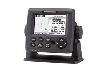 Raymarine AIS650 Transceiver and RaymarineeS9 HybridTouch Display
Operating in the VHF maritime band, the Raymarine AIS system enables the wireless exchange of navigation status between vessels and shore-side traffic monitoring centres. Commercial ships, ocean-going vessels and recreational boats equipped with Raymarine AIS transmitters broadcast AIS messages that include the vessel’s name, course, speed and current navigation status.
The AIS650 features dual channel receivers for AIS vessel monitoring of class A and B transmissions and a dedicated 50 channel RAIM compliant GPS receiver for superior accuracy. The AIS650 also has hardware and software selectable Silent Mode for privacy or security. Silent mode turns off your AIS transmitter while still enabling you to see transmissions from other vessels. There is an SD Card Slot for recording of AIS data and a built-in NMEA multiplexer simplifies integration with legacy Multifunction Displays, VHF radios and 3rd party devices making it weasier to upgrade to this AIS system.
www.raymarine.com
While AIS technology is capable of disseminating a wide range of information, its most common use is to allow mariners to “see” other nearby traffic to avoid vessel-to-vessel collisions. The basic concept is fairly simple. An onboard AIS transponderbroadcasts a vessel’s speed, course and location information from its GPS—along with the vessel’s unique,nine-digit Maritime Mobile Service Identity (MMSI) number, which is assigned by Industry Canada – part of Innovation, Science and Economic Development Canada—over VHF channels, while also listening for other vessels’ incoming signals. Critically, properly programmed MMSI numbers allow a mariner to directly call another vessel (think of a cell-phone number), rather than relying on easily missed VHF broadcasts. Equipment depending, AIS information can be overlaid onto an electronic nautical chart (or radar display), giving navigators a tremendous level of big-picture awareness, especially when paired with radar imagery.
There are two types of AIS available to mariners, namely Class A and Class B devices. Class A AIS is typically used by commercial traffic (or for fast-moving recreational traffic) and features 2-12.5 Watts of transmitting power. Class A transponders have a variable reporting rate that ranges fromonce every two to ten seconds, depending on the vessel’s speed (this rate drops to once every three minutes if the vessel is traveling at less than three knots, and once every six minutes when the vessel is anchored). Class A units are required to have a dedicated Multiple Keyboard Display (MKD), and contemporary Class A units are designed to display both Class A and Class B AIS target information. Critically, Class A units broadcast their transmissions using the Self-Organizing Time-Division Multiple Access (SOTDMA) scheme, which is an automated method that allows different users to efficiently share finite channel access.
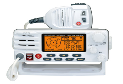 Standard Horizon GX2200 Matrix AIS/GPS
In the July/August Marine Electronics Journal, the Standard Horizon GX2200 Matrix AIS/GPS was recognized as one of the Top 128 products. They said, “The GX2200 Matrix AIS/GPS features an integrated 66 channel WAAS GPS antenna, so there’s no need to hassle with wiring the radio to a GPS for DSC or AIS. Out-of-the-box and ready to go, it acquires GPS position, AIS and AIS SART targets. One antenna input is all that’s needed to receive AIS targets from both class A and class B transponders. It’s a VHF radio that solves a whole range of needs, perfect for recreational boaters. Having a VHF with DSC and integrated AIS/GPS provides real piece of mind in high traffic areas.
www.standardhorizon.com
Class B AIS is primarily aimed at the recreational marine market (although it has some commercial applications) and will eventually be available in two varieties, AIS Class B/SO, which uses the same self-organizing SOTDMA scheme as Class A units, and AIS Class B/CS, which uses a Carrier Sense Time Division Multiple Access (CSTDMA) scheme to share channel access. Unlike the SOTDMAscheme, which pre-announces the time slots when it will be transmitting, AIS Class B/CS units continually monitor the frequencies and select unused slots.Moreover AIS Class B/SO units feature two to five Watts of transmitting power and a reporting rate that ranges between once every five to 30 seconds, depending on vessel speed. AIS Class B/CS units feature two Watts of transmitting power and a static reporting rate of once every 30 seconds. Both units reduce their reporting rate to once every three minutes for vessels traveling at less than two knots, and once every six minutes for static data.Given that most cruising yachts travel at speeds well-below 20 knots (the speed at which reporting rates become germane, as fast boats can outpace their reporting rates when using AIS Class B/CS), most cruisers can safely spec an AIS Class B/CS transponder, provided that they do not require the extra range afforded bya Class A or Class B/SO unit’sadditional power.[N.B., while the United States Coast Guard (USCG) has approved AIS Class B/SO units—as of this writing—they are not yet commercially available.]
While Class B/SO units are required to have a dedicated MKD, displays are optional for Class B/CS units. Because of this, many AIS manufacturers build black-box Class B/CS units, which are networked with the vessel’s multi-function display (MFD) in order to graphically present its target list atop cartography. Equipment depending, Class B units are compatible with NMEA 0183 (and sometimes NMEA 2000) data backbones, making it easy to network the AIS device to a MFD.
A third type of Class B AIS is available that allows mariners to listen to incoming AIS transmission but which does not broadcast its own navigational information. These AIS receivers are popular,but it’s critical to remember that while you can see other maritime traffic via these devices, this traffic is blind to your positionunless they see you on their radar or with their eyeballs.
In all cases, the biggest difference between these AIS units is their power, range, and reporting rates.
All AIS signals can be “heard” by nearby vessels and aircraft, as well as shore-based facilities, such as the USCG’s Nationwide AIS (NAIS) base stations, allowing theUSCG to monitor maritime traffic and use AIS as a Vessel Traffic Service tool. Since AIS uses line-of-sight VHF communications, range is typically limited to 10-20 miles, with masthead antennas delivering better performance than obstructed antennas; also, shore-based repeater stations can substantially extend this range. While an AIS unit’s range is limited, it offers better propagation than radar, allowing AIS signals to ‘peer around’ low-slung islands andmaking this technology ideally suited for areas such asThe Thousand Islandsorthe Pacific North West.
While mariners commonly use AIS for collision avoidance, the USCGalso employs the technology to mark navigational hazards by broadcasting synthetic Aids to Navigation (AtoNs), which are transmitted by anNAIS station to augment an existing charted buoy or aid, and virtual AtoNs, which are AIS signals only (i.e., no physical AtoNs) in areas that are difficult to mark with physical AtoNs.
The buoys marking Michigan’s Straits of Mackinac are a prime example of synthetic AtoNs include, while the approach to San Francisco Bay is marked by virtual AtoNs.
The USCG is also looking at other ways of leveraging AIS, as this technology has the unique ability (equipment depending) to deliver updateable messages to a commercial ship’s Electronic Chart Display and Information System (ECDIS) or onto a recreational vessel’s MFD. According to the USCG’s “21st Century Waterway Listening Session 2014” (available on YouTube), the “U.S. vision for e-Navigation is to establish a framework that enables the transfer of data between and among ships and shore facilities, and that integrates and transforms that data in decision and action information.” This vision includes synthetic and virtual AtoNs, as well as Application Specific Messages (ASMs), which can be broadcast over AIS in order to cordon-off specific zones (e.g. whale-exclusion zones or to protect maritime traffic from recently sunken vessels), shift shipping channels, or augment its Broadcast Notice to Mariners; moving forward, the USCG and NOAA plan to use AIS to share their Physical Oceanographic Real-Time System information (e.g. real-time weather observations and geospatial data) with mariners.
“AIS is currently the only tool to transfer digital data onto your electronic-nautical chart ” said Jorge Arroyo, a USCG program analyst who has been instrumental in writing AIS regulations and standards, referring to the Application Specific Messages (ASMs) that the USCG can broadcast via AIS. “The ASM is the envelope. Within the envelope [the USCG] is free to transmit all the other navigation-specific information that we wish… It’s our way of providing digital navigational data directly to the vessel.”
Additionally, Vesper Marine, a New Zealand-based manufacturer of Wi-Fi enabled Class B transponders, recently announced their WatchMate Asset Protection service, which allows companies (e.g., oil or gas firms) to add virtual AIS beaconsto sensitive static installations (i.e., an oil rig or underwater power lines), so as to help ensure that maritime traffic does not accidentally collide with these objects.The WatchMate Asset Protection service also provides 24/7 asset monitoring, threat detection, and the ability to automatically send AIS text messages to targets of interest warning of thenavigational hazard(s).
Given the amount of germane navigational information that an AIS unit can provide, adopting this technology is a no-brainer for all cruisers, especially as more manufacturers enter the market and prices drop. While it’s tempting to reach for an inexpensive Class B receive-only unit, some cruising rallies and offshore races now require that entrants carry AIS transponders, making this a strong consideration. Moreover, the amount of added protection that an AIS transponder offers is well worth the additional monies, especially for shorthanded or singlehanded cruisers.
While the “Big Four” manufacturers (B&G, Furuno, Garmin and Raymarine) have offered Class A and Class B AIS units for years, other important players in this market include Vesper Marine, which makes a variety of AIS-related products and Standard Horizon, who have been embedding AIS technology into their fixed-mount VHFs (N.B, B&G, Garmin, Icom and Raymarine also build AIS-enabled VHFs).More recently, players such as ACR Electronics, McMurdo and NKE have entered the AIS market with a range of innovative AIS products that offer users options and (equipment depending) networking flexibility.
AIS Carriage Requirements
While AIS can be a huge aide to safety—day or night—the USCG does not require all mariners to carry this equipment. Here’s a breakdown of the kind of vessels that are required to carry properly installed USCG type-approved AIS transponders in U.S. waters.
Class A AIS:
—Commercial self-propelled vessels of 65 feet or greater.
—Commercial towing vessels of 26 feet or greater and over 600 horsepower.
—Self-powered vessels USCG certificated to carry more than 150 passengers, or that move certain dangerous, flammable or combustible cargoes in bulk.
—Commercial motorized dredging vessels that work in a way that’s likely to interfere with the safe navigation of other commercial vessels.
Class B AIS:
—Commercial-fishing vessels and most passenger vessels that operate outside a USCG Vessel Traffic Service or Vessel Movement Reporting Area may use a lower-cost, fully compatible AIS Class B in lieu of Class A device.
While recreational boaters aren’t legally required to carry AIS, a recent change (dated March 2, 2015) to the USCG’s AIS requirements pertains to “any vessel equipped with AIS”, meaning that all recreational boaters who elect to carry AIS must abide by some of the USCG’s new AIS operations requirements as to how they use their AIS. See www.navcen.uscg.gov AIS Frequently Asked Questions for more information.
—DS
Rules of the AIS Road
AIS is designed to operate autonomously and continuously, thus it’s imperative that it be properly set-up. Careful consideration should be taken in its installation (e.g., to ensure that it’s near the vessel’s conning position), and to the potential of electronic interference from other radios or other onboard electrical equipment. Irrespective of whether you run a Class A or Class B AIS transmitter on your boat, it must properly identify itself with its official MMSI number, which is issued by the FCC or their agent. Users must always maintain their AIS equipment in “effective operating condition” (read: capable of proper continuous operation), and learn how re-initialize it (read: know your system password [Class A AIS users only] and the antenna location parameters). Required users must turn-on their AIS transponders 15 minutes before unmooring, and to keep it turned-on while they are underway or at anchor, unless this action would compromise the vessel’s safety or security. Class A AIS users should ensure accurate upkeep of all AIS voyage-related data fields (e.g., navigation status, static draft and destination), and to always use English for AIS text messaging.
—DS
AIS Manufacturers
ACR Electronics, Inc., www.acrartex.com
B&G,www.bandg.com
Digital Yacht,www.digitalyacht.co.uk
Em-Trak, www.em-trak
Furuno,www.furunousa.com
Garmin,www.garmin.com
Icom, www.icomamerica.com
McMurdo,www.mcmurdomarine.com
NKE Marine Electronics, www.nke-marine-electronics.com
Raymarine, www.raymarine.com
Standard Horizon,www.standardhorizon.com
SI-TEX, www.si-tex.com
Vesper Marine Ltd.,www.vespermarine.com
—DS
