Northern Scotland: Voyage to Orkney and Shetland Isles
Paul and Sheryl Shard continue their adventures cruising in Scotland aboard their Southerly 49 sailboat, Distant Shores II.
The Muckle Flugga light at 60º 51’N 0º53’W marks the most northern point of the United Kingdom. Our quest to reach it aboard our Southerly 49 sailboat, Distant Shores II, took us through some of the United Kingdom’s most remote and charming island groups, the Orkney and Shetland Isles.
These island groups lie off the north coast of the Scottish mainland; although both are territories of Scotland, the people seem to identify more strongly with their Nordic roots. For centuries, Viking kings ruled the islands — which are only a short sailing distance across the North Sea from Norway. Lerwick, the capital of the Shetland Islands, is a mere 195 nm to the Marstein light at 60º 8’N 5º 4.5’E on the west coast of Norway. The Marstein light marks the entrance to the fjord leading into the major Norwegian port of Bergen. (See www.canadianyachting.ca, Home, Digital, Back Issues, August 2012, page 8 for our article on “Cruising the Fjords of Norway” for more information 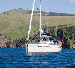 on making this passage.)
Fishing and seafaring are important and honoured livelihoods in the islands so there is much “back-and-forthness” that encourages cultural exchange between Orkney, Shetland, and Norway. During World War II, the Shetland Bus was established — a special operations boat-based link between Shetland and German-occupied Norway that moved people and supplies under the cover of darkness and in conditions of poor visibility and foul weather across the North Sea. To this day, the bond the Shetland Bus created remains strong.
We began our cruise of the Orkney and Shetland archipelagos in mid-June following an east-to-west transit of Scotland’s Caledonian Canal from Fort William to Inverness (See www.canadianyachting.ca, Home, Digital, Back Issues, June 2012, page 6). On June 17, we raised anchor in a misty sunrise at the anchorage in Kessock Road, near Inverness, to sail north up the last stretch of Scotland’s east coast timing our departure for favourable tides and a safe crossing of the Pentland Firth.
 The Pentland Firth is a notorious strait separating the Orkney archipelago from the mainland of Scotland and has some of the strongest and fastest tides in the world. Speeds of 16 knots or 30 km/hr have been recorded, which is fast enough to waterski! In normal high tide and current conditions six and eight knots can be expected as well as “roosts,” which occur when the tide brings water in and meets waves coming from the other side forming massive standing waves. At maximum tide and current, the shoal-strewn Pentland Firth is generally not the place you want to be in a sailboat. We were blessed with light-wind conditions and a pleasant sail across the strait to reach the Orkney Isles on calm seas.
Orkney is an archipelago of 70 or so low-lying islands located about 10 nm north of the Scottish mainland; it has been home to mankind since about 4,000 B.C. Of the 70 islands, only 20 are inhabited, and most of the 20,000 people live on the largest island called Mainland where Orkney’s two main towns, Kirkwall and Stromness, are located as well as the large natural harbour of Skapa Flow. The islands played an important part in the development of Canada’s history since Stromness was a major recruiting and 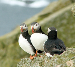 supply base for the Hudson’s Bay Company. If you sail out into the Atlantic Ocean from Stromness, the next stop is Canada.
A great aspect of cruising in this region is that you are so far north that you have lasting daylight in the summer months. This means you can cover a lot of ground between sunrise and sunset — especially if you ride the tides. Plenty of daylight remained at 19:30 on June 17 when, after a passage of 98 nm, we reached our first anchorage in Orkney at East Weddel Sound in Holm Sound between Mainland and Burray just outside the huge natural harbour of Skapa Flow.
We were the only boat floating in the anchorage. Surrounding us were World War II blockships — purposely sunk to prevent German U-boats, which could hold up to a hundred naval ships, from entering the harbour. On shore, concrete gun emplacements stand out against vibrant green fields. In both World Wars, Skapa Flow was the main base for the British Royal Navy. However on October 14, 1939, a U-47 slipped through and sank the World War I-era battleship, HMS Royal Oak. As a result, Prime Minister Winston Churchill ordered the construction of a series of causeways to completely block the eastern approaches to Skapa Flow. 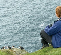 The Churchill Barriers now provide road access from Mainland to Burray and South Ronaldsay, and still block all ship traffic into the harbour. But they make this cove on the outside a secure and interesting anchorage. Before the sun set we launched the dinghy and went to take a look at the wrecks.
One of the most significant events in naval history at Skapa Flow occurred here in World War I when the German fleet purposefully sank their own ships. At the end of the First World War the entire fleet was interned here while peace negotiations were underway. The German admiral, fearing that either hostility might recommence or the entire fleet would be given to the Allies, decided to scupper the fleet and had 74 ships sunk in the harbour at Skapa Flow. A huge salvage operation took place after the scuttling of the German High Seas fleet in 1919 but seven warships and four destroyers still lie on the bottom and have become popular dive sites. Novice divers can enjoy exploring the blockship wrecks in the Holm Sound anchorage which is shallower than the deep water of the main harbour.
The summer season is short in this part of the world and our strategy was to get north as quickly as possible and then work our way south. Rather than exploring Orkney now, we decided to shoot north up to Shetland, make the jump to 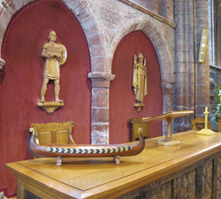 Norway, and then cruise Orkney and Shetland thoroughly and in a relaxed fashion on our way south travelling with, rather than against, the season.
On June 19, we set sail for Fair Isle in the Shetland archipelago. Once again we had light winds but enough for a pleasant sail. We dressed in full foul weather gear all summer due to the temperature. If it’s suntanning you’re after, this is not the cruising ground for you!
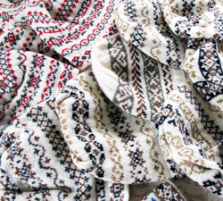
Fair Isle is the most southerly of the Shetland Islands and lies almost 30 miles north-east of Orkney and about 25 miles south-west of Shetland’s Mainland, making it the most remote island in the United Kingdom and a breeding ground for many species of birds. You may have heard of Fair Isle sweaters which have traditional patterns and are produced by the islanders from the fine Fair Isle sheep’s wool.
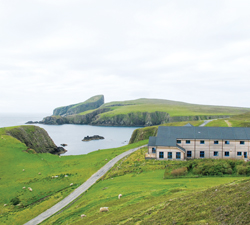
We made landfall at South Light and it’s at this end of Fair Isle that most of the 70 islanders live. Fair Isle’s most distinctive landmark is Sheep Rock. At 100 metres tall, it gets its name from the days when grazing lands were scarce 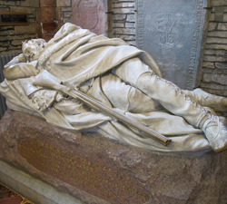 and islanders used to haul sheep up to graze there. We passed this magnificent landmark to arrive at the small harbour at North Haven. The island’s ferry, called The Good Shepherd, is docked here. Although there’s a small airstrip, The Good Shepherd is the main link to the outside world.
Fair Isle is just three miles long and 1.5 miles wide. Since 1954, the island has been owned by the National Trust for Scotland, ensuring that the special eco-system of Fair Isle is protected. An abundance of wildflowers colour the harsh landscape here and you’ll also find a profusion of lichen rarely seen in less pristine environments.
We came here to learn more about seabirds, especially puffins, who breed in the cliffs of Fair Isle during the spring and summer months. There has been a permanent bird observatory on Fair Isle since 1948 due to the number and variety of birds that migrate and breed here throughout the year. The observatory lodge near the harbour provides most of the visitor accommodation on the island and free guided walks are offered by the rangers. Visiting sailors can make reservations at the restaurant there and participate in the activities. Wearing our new Fair Isle hats, we went out with Ranger Carrie at 10 o’clock at night with enough daylight 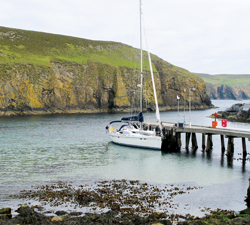 to see and learn about the hundreds of puffins, gannets and “bonxies” that breed here in the spring and summer months.
As we talk, puffins come and go from their burrows in the cliffs at our feet. We learn that like most sea birds they actually spend the winter out at sea and then come to land for their breeding season from early April to the end of July. When the breeding season ends, the puffins leave with their young to go back out to sea. Nobody knows exactly where they go, but apparently they’re quite keen to come back to their original breeding ground and return to the same site year after year. Through a careful tagging procedure, which visitors can participate in, the rangers can see which birds have survived the previous winter. If you’re interested in seeing seabirds, they’re pretty much guaranteed here from late April through to the end of July.
The northern part of Fair Isle is rocky moorland so it is used as common grazing land for the islanders’ sheep. The southern part of Fair Isle offers more shelter, the land flatter and more arable — hence the reason why the majority of the 70 islanders live here where there are two churches, a small shop, a post office and a schoolhouse. Most of the islanders live on crofts. Crofting is a form of land tenure where small-scale or self-sufficient food production is carried out. Due to the severity of the environment here, most crofters on Fair Isle farm sheep for meat and wool. Many islanders are involved in craftwork activities related to the fine wool produced here — spinning and knitting goods using the traditional Fair Isle patterns.
June 21 is the summer solstice, the longest day of the year, and we experienced almost 24 hours of daylight on Fair Isle. In the wee hours there was almost a ghostly bluish light in the air similar to the light during an eclipse of the sun. It was bizarre to see sheep lying asleep while a few islanders tended their gardens at 2 a.m. in a strange twilight. It’s hard to get to sleep when it’s daylight for so much of the day.
We left the next day sailing north to the island of Mainland of Shetland and arrived in the capital city of Lerwick where there is a very good harbour for recreational boats as well as the commercial harbour. When we checked in with the port authority we were given a key to the Lerwick Boating Club where there were showers and laundry facilities and a very welcoming community of local boaters.
At the Lerwick Boating Club we met up with cruising friends, Liz and Archie, who took us to local events like their dance club dinner for some Scottish country dancing. They also showed us some of the lovely sites around the Shetland Mainland. There are some beautiful beaches in Shetland, but at this latitude even in mid-summer you have to dress warmly to enjoy them.
Of course, we wanted to see Shetland ponies in their homeland. Although small, Shetland ponies are the strongest breed of horse or pony, being able to pull twice their own weight in situations where a draft horse could only pull about half its weight. It’s not surprising that they have been the primary pack and saddle animal in the Shetland Islands since the Bronze Age.
Lerwick means “the muddy bay” or “bay of clay” in the old Norse tongue. For more than 500 years the Norse controlled the Shetland Islands, but they were given to Scotland in 1468 as part of a marriage dowry. At this time Lerwick was still just a muddy bay — it wasn’t until the 1600s that a small settlement started here to trade with and supply the Dutch fishing fleet.
While we were in Lerwick the annual Shetland-Bergen sailing race took place. This is the largest ocean racing event in the North Sea and happens on the last weekend of June. The race goes between Bergen on the west coast of Norway and Lerwick.
It didn’t take long before there was a cèilidh going on at the Lerwick Boating Club with tired bodies packing in to enjoy a pint, the company of fellow sailors, and traditional Shetland music. A cèilidh is a traditional social gathering often held spontaneously in Gaelic culture. The music is so joyful it can’t help but raise the spirits of even the most exhausted sailors. Meanwhile, race boats were still coming in across the finish line. Almost 40 boats compete in the Bergen-Shetland Race each year, an event that has been taking place for over 20 years. The last of the boats came in around midnight, with light still in the sky.
Following the return race across the North Sea from Lerwick to Bergen on June 26, we set sail up to the Shetland island of Unst with Liz and Archie aboard. It was a great chance to catch up and benefit from their local knowledge.
Unst is the most northerly of the British Isles, in the northern Shetlands. The population of Unst is less than 700 — down from when the military base manning the old Distant Early Warning station was a major economic engine. This is the most northern point of Britain, back in the cold war they set up a station here to warn of Soviet attacks. The station is still there but abandoned. Now tourism is a large factor in the local economy and a special draw is the Hermaness Bird Sanctuary at the north end of Unst.
There aren’t many harbours in the Shetland Islands, but the indented coastline means there are a number of anchorages we can use depending on the winds. We lucked out with light winds from the south so we anchored at the large sea inlet at the north end of the island within view of the famous rock, Muckle Flugga, which you have to say carefully. We were in the most northern anchorage in the most northern island of the British Isles. Cool!
One famous former visitor to Unst was author Robert Louis Stevenson. Stevenson’s father and uncle were the main design engineers for the lighthouse on Muckle Flugga. Stevenson wrote Treasure Island — many people say he based the island on Unst. I compare our chart with his original drawing and it is a very good match. We anchored in the bay Stevenson called North Inlet in the story where his hero deliberately ran the Hispaniola right up on this very beach. But today, with south winds predicted we should be safe to leave Distant Shores at anchor here for a few hours. There are hundreds of seabirds — and hundreds of midges too!
Liz and Archie took the ferry home to Lerwick and we set sailed across the North Sea to Norway (See www.canadianyachting.ca, Home, Digital, Back Issues, August 2012, page 8) returning to Lerwick and clearing back into the European Union and the Shetland Islands on July 28.
From there we continued our southbound voyage back to Orkney. (Note: The islanders hate it if you call the islands, “the Orkneys,” or “the Shetlands.” You can say, “Orkney,” “Orkney Isles,” “Orkney Islands,” “Islands of Orkney,” or “Archipelago of Orkney.” Ditto for Shetland.)
Our first stop in Orkney on the way south was at the small island of Stronsay. We tied up at the town quay in the harbour of Whitehall which is also used by the monks whose monastery is across the harbour on the island of Papa Stronsay. Their presence adds to the sense of peacefulness and timelessness here. In the early 20th century, Whitehall was one of the herring capitals of Europe and a developing boom town. But all is quiet now and although fishing is still important to the survival of the people here, it is on a considerably smaller scale. At the town quay we also have a surprise meeting with Dutch sailor and yacht designer, Dick Coopman Jr., and his wife, Jolande. Paul corresponded with Dick when we were searching for a new shoal-draft yacht so it was a delight to finally meet him and Jolande in person aboard our boats in such a remote place.
Twenty years ago, Jolande worked in Orkney as an archaeologist and wanted to sail back to see the progression of the excavations. We sailed on to meet up again in Kirkwall, the capital city and main harbour, on Mainland to visit the fantastic Neolithic sites with them. Timing the tides and currents around the island of Orkney is tricky because of their strength, and it was also the full moon.
Kirkwall is a Viking town founded around 1035. It has a busy port where the local fishing fleet and island ferries are based. It also has a 95-berth marina which we made our base. The name Kirkwall comes from the old Norse word for “church bay” but refers to a much older church than the impressive St. Magnus Cathedral that dominates the skyline. St. Magnus Cathedral was founded in 1137 by the Vikings. The beautiful sandstone cathedral is considered one of the finest medieval buildings in the north of Scotland.
From Kirkwall, we make an outing by car with Dick, Jolande, and local sailors from the Kirkwall Sailing Club to the Heart of Neolithic Orkney, a name given to a group of impressive Neolithic monuments found on West Mainland. Included are the Ring of Brodgar, the Standing Stones of Stenness, the Neolithic village of Skara Brae, and the passage grave of Maeshowe.
Maeshowe is a unique chambered cairn and passage grave, aligned so that its central chamber illuminates on the winter solstice. The side of the entrance is one long solid piece of stone. Centuries after it was built, looting Vikings came ashore in bad weather and left one of the largest collections of runic inscriptions in the world. It turns out that young Viking men were not so different from some young men of today. When translated, many of the messages were typical graffiti about who did it with whom.
The maritime, military and ancient historical sites in the islands of Orkney and Shetland all relate to seafaring people. The wildlife and natural beauty is breath-taking and the navigational challenges, thrilling. Despite the cool summer weather the Orkney and Shetland Isles in North Scotland are fantastic cruising grounds and not to be missed.
Photo Captions:
1: Harbour at North Haven, Fair Isle, & Bird Observatory
2: As above from the harbour with Distant Shores II in front
3: Knitted hats in Fair Isle patterns
4 & 5: Puffins
6: Interior of St. Magnus cathedral built by Vikings in 1137
7: Tomb of John Rae, discoverer of Northwest Passage
8: Distant Shores II, North Haven, Fair Isle
Award-winning filmmakers and sailing authors, Paul and Sheryl Shard, have been cruising internationally since 1989. They are the hosts of the sailing adventure TV series, Distant Shores, which airs weekdays across Canada on Travel and Escape Channel and includes episodes on their cruise of Orkney and Shetland. Visit their website at www.distantshores.ca and meet them at the Toronto International Boat Show on January 18–20, 2013.