Harmony Islands, BC
En route to Princess Louisa Inlet, this marine park offers tranquil refuge in a truly spectacular setting.
After spending three wonderful days relaxing, exploring and visiting with other boaters in Princess Louisa Inlet, my wife Arlene and I departed, retracing our track back out through Jervis Inlet’s Queens, Princess Royal and Prince of Wales Reaches. The granite mountain slopes shone brilliantly in the morning sun. It was easy to imagine how the intense weight of massive glacier flows carved out these mountains and polished the hard granite to a shiny brilliance. Below the granite walls, thick forest, dissected by waterfalls, descended to the shoreline.
Three hours after our departure, we rounded Foley Head and entered Hotham Sound, near the entrance to Jervis Inlet. Some of the deepest water on the BC coast is found here – over 2,200 feet or more than a third of a nautical mile. The inviting Harmony Islands were in sight four miles ahead, with forest-clad Mt. Calder (1,465 meters) providing a stunning backdrop.
 As we approached, we passed the impressive 427-meter Freil Falls, the gatekeeper of Hotham Sound. Its water cascades from hidden Freil Lake, near the mountaintop, down an almost sheer rock cliff face. This is one of the largest freestanding waterfalls on Canada’s west coast. The best time to view the falls is in spring and early summer when water flows reach their maximum.
The falls are approximately a mile southeast of the Harmony Islands. Once visitors drop anchor and settle in, some dinghy or kayak to the falls to take in its beauty and thundering sound. The more adventurous go ashore and explore the base of the falls. This can be fun but be advised that the rock surfaces can be slippery. Those with a strong heart can take a truly natural and invigorating shower!
Hotham Sound is the ancestral home of the Sechelt First Nations people, and members of the Sechelt Band continue to live throughout the Sunshine Coast area. The Harmony Islands were named by Dr. Campbell Balmer, a Vancouver dentist who, with two friends, purchased the four islands in 1932 for $248. Every summer Balmer, his family and friends would 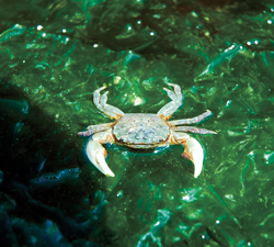 cruise their boats to the islands. Their nearest neighbour was a hermit who lived three miles away in St. Vincent Bay, for whom they would bring fresh bread and pipe tobacco whenever they visited. During the Second World War, when fuel was rationed, Balmer and his friends sold the islands. Portions of the island group became a provincial marine park in 1992.
Refuge
The Harmony Islands lie on the east side of Hotham Sound, north of Granville Bay. The marine park consists of the southernmost of the four Islands, the smaller northernmost island, and most of the inside foreshore. The other islands are privately owned and visitors are requested to not trespass on them. The adjacent waters in the channel between the islands and the mainland are also within the park boundaries; the total park area is over 31 hectares.
One of the park’s chief attributes is the refuge it provides for boaters and kayakers in a locale that sees lots of boat traffic 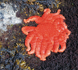 but where channels are mostly deep and anchorages few and far between. Not surprisingly, the park is popular and may be congested during long weekends and summer months. The southernmost island provides flat, grassy spots for kayakers to beach their craft and set up camp. To help preserve its natural beauty, the park has been designated a sewage no-discharge zone.
The islands offer a tranquil, barebones gunkhole off the beaten path, with no facilities or development but simply amazing marine scenery. The most sheltered anchorage is in the tiny basin (known locally as Kipling Cove) created by the natural formation of the three northern islands. The cove offers dramatic vistas, warm-water swimming, good snorkeling and safe anchorage. However, caution must be exercised when entering: charts show a rock in the middle of the entrance, which at low tide is covered by about three feet of water. Space is limited, so most boaters elect to tie a stern line to one of the metal rings set into the rock on shore for this purpose. This prevents boats from swinging freely at anchor, allowing space for more visitors.
 Gunkholing
We entered the islands by rounding the northernmost island from the west. There was a boat anchored in a popular location between the two northern islands with a beautiful view of Kipling Cove off their stern. So we continued down the east side of the islands in the narrow channel that separates them from the mainland. It’s possible to anchor in this reasonably protected channel but be sure to consult a detailed large-scale chart and beware of shallow water in the passage.
We found three boats anchored in Kipling Cove and a few more in the channel. We always look for seclusion and new anchorages so we continued south down the east side of the islands. We found a small nook on the southeast shore of the southernmost island and we decided to tuck Easy Goin’ into the nook with a stern-tie (see sidebar).
Once we were secure in our peaceful and protected anchorage, we enjoyed lunch and took in the scenery, the wildlife and nearby Mt. Calder. Later, we dinghied to the oyster and clam-covered shoreline. We explored the island’s many tide 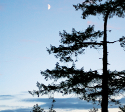 pools, took photos to preserve the memories, then relaxed on the dried grass in the warm afternoon sun. At high water, the dinghy pass between the private islands is fun to explore. It also provides a convenient route to and from the park’s southern and northern islands.
Before returning to Easy Goin’, we gathered a few small oysters, which are abundant, to enjoy on the half-shell as appetizers during happy hour.
As the day drew to an end and the sun set, we settled in on the back deck in the warm evening air and watched the waxing moon rise over our private little Harmony Island. It was a fitting close to a wonderful day.
Deane and Arlene Hislop cruise Easy Goin’, a Meridian 381, from Anacortes, Washington. Deane has been boating for 40 years.
Stern-Tying 101
In busy West Coast anchorages, stern-tying is a common option. We don’t often choose anchorages that are busy, usually favouring less-traveled areas. But we still stern-tie frequently as a way of tucking into beautiful little spots where there just isn’t the room to swing freely.
In Harmony Islands Marine Park, with Arlene at the helm on the bridge and me on the bow, we first set the anchor in 24’ of water over a mixed mud and rock bottom in front of our chosen nook. Then we backed Easy Goin’ into the small cove with the stern toward the shore. Arlene held the boat in position while I took the stern line ashore with the dinghy.
With no park rings handy, I looped the line around a fallen tree and took it back to the boat, where we tied the bitter end to the starboard stern cleat. I pulled the other end of the line taut, leaving enough slack to accommodate the rise and fall of the tide, and secured that end to the port cleat. When it’s time to depart, we simply release the line from the cleats and pull it back to the boat.
Here on the west coast, the most commonly carried stern line for boats up to about 50’ is 300 to 600’ of half-inch polypropylene. We carry 660’ on a plastic garden hose reel that we store on the bridge, and we have found it to be more than sufficient and easy to use.
Polypropylene is preferred because it floats (it won’t sink and foul propellers or running gear), its yellow colour is highly visible, and it’s inexpensive. However, it is more susceptible to ultraviolet degradation than most other line types, so our hose reel has a lid which protects the line from harmful light. Some boaters store their stern line on a reel mounted on deck with a canvas cover for protection from the elements.
In recent years, there has been concern voiced about the risk of damage to living trees as a result of stern-tying. If you run the line around a living tree the line may cut the bark, which could harm the tree. To prevent this, run stern lines to shore rings where possible or choose a snag, deadfall or rock instead. If you have to use a living tree, wrap an old towel around the line to protect the bark.
Details & Coordinates
Charts: 3514, 3512 and Chartbook 3312
Hazards: Rock in entrance to Kipling Cove
Attractions: Cozy, relaxing undeveloped setting, spectacular scenery and good dinghy exploring
Weather: VHF Ch WX1 or 250-339-0748 (Comox Radio)
Nearest Fuel and Provisions: Bathgate General Store and Marina at Egmont
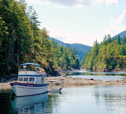
Photo 1: Cruisers find multiple nooks for anchoring, like this one at the north end of the islands, with Kipling Cove astern.
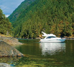
Photo 2: Easy Goin’ is anchored in the shadow of Mt. Calder, Harmony Islands.
Photo 3: Shore crab caught in one of the many Harmony Island tidal pools
Photo 4: The islands’ tide pools are home to a variety of wildlife, including this sunflower star and shore crabs
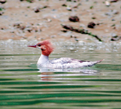
Photo 5: A female common merganser cruises through a Harmony Island anchorage
Photo 6: The moon rises over the Harmony Islands.
Story & Photos by Deane Hislop