Brittany Coast of France
Completing the Tour of the Six Celtic Nations
Sheryl and Paul Shard continue their sailing adventures with an autumn cruise of the Brittany coast of France aboard their Southerly 49 sailboat, Distant Shores II.
It was a chilly and challenging summer aboard our Southerly 49 sailboat, Distant Shores II, exploring the beautiful west coast of Norway as far as 61°N and also the Celtic nations of Ireland, Northern Ireland, Isle of Man, Wales and Scotland including the Shetland and Orkney Isles.
By early September, the season had definitely come to an end and we worked our way south again through the Irish Sea to the Cornish coast of England. Temperatures improved somewhat at the lower latitude here, and when we sailed into the huge natural harbour of Falmouth at 50°N we were able to reduce the layers of foul weather gear that encased us all summer. The North Atlantic Drift, which is an extension of the Gulf Stream, a huge ocean current originating in the tropics, has a very positive effect on this coast. Palm trees grow here and Cornish sailors get out on the water all year long.
We planned the year’s cruise to take advantage of the moderate autumn temperatures in this region and extend the cruising season a little after our trip north. There was one more Celtic region we wanted to investigate to complete our visit to the Six Celtic Nations before storing our boat for the winter. This was Brittany, located on the northwest coast of France, a nightsail south from Falmouth across the English Channel.
 There are six territories considered Celtic nations (or territories) in Europe where Celtic traditions of music, culture and language have survived, resulting in a shared common identity. These six nations are the Brittany region that we had yet to visit, Cornwall on the west coast of England, Ireland, the Isle of Man, Scotland and Wales. Before the expansions of the Roman Republic and Germanic tribes, a large part of Europe was Celtic.
With a good weather forecast, we left Falmouth on a warm sunny evening at the end of September. We set sail overnight across the English Channel, arriving near the French coast at daylight. It was important to time the tide; we needed favourable currents through the Chenal du Four at the northwest corner of France.
The Chenal du Four lies between the most western point of the French mainland and the Île d’Ouessant, in English called Ushant. Passing through the Chenal du Four saves considerable time and distance as opposed to going around the outside. We’d been told it was a much more comfortable passage if you timed the tides right. The tides funnel through here accelerating the current; you want to be going with them rather than against them.
Veteran cruiser and author of the Wiley Nautical Cruising Companion, West France, our cruising guide of choice in Brittany, describes the Chenal du Four as “more than just a corridor through which yachts rush south to better weather and finer wines; or northwards to get back into the office on Monday. It is a cruising ground in its own right…”
 Since our time was short, we opted to get as far south on the Brittany coast as the end-of-season would allow and to explore the Chenal du Four area on the way back to England at the end of October. For us it was “a corridor to rush south to better weather and finer wines,” and when daylight arrived after a foggy night crossing of the English Channel we shot through like a rocket with the current and exited at slack water just before the tide turned.
There are lots of rocks and dangers to navigate here, and throughout history there have been numerous shipwrecks. One of the major landmarks is the Pointe du St. Mathieu on the mainland with its lighthouse, coast guard station and ruined Abbey, founded in the 6th century. Since the Abbey overlooks this dangerous passage, it was officially given the right to 10 percent of the proceeds from the “hull, cargo and rigging of wrecked ships.” An unusual way to generate funds for a spiritual institution, but apparently they also provide assistance to victims.
One of the most popular cruising grounds on the South Brittany coast is the Gulf of Morbihan or in the Breton language, Ar Mor Bihan, which means “the little sea.” It is actually a large, natural harbour containing about 40 islands — depending on the tide. Many of our cruising friends have spent whole summers exploring the area and begged us not to miss it. However, time did not allow but I mention it in case you find yourself in the neighbourhood or currently planning a cruise of Brittany.
 Our furthest point south and next on the list of must-see places was the Glenan Islands or Îles de Glénan at 47º 42’N 03º 59’W. It took a couple of hops down the coast to reach this rocky but romantically beautiful archipelago. There are eight major islands — most encircled by glistening white sand beaches — and numerous islets and countless drying rocks. Since the anchorages are quite exposed to wind and high tide, you can only visit here in the most settled weather.
Getting the right conditions in October is unusual, but we lucked out and spent a couple of hot sunny days at anchor here. The beauty of the archipelago’s location is that it is only 10 nm from the mainland ports of Loctudy, Bénodet, Port-le-Forêt and Concarneau; if the weather turns, you can always make a run for it. While we were there, many local boats came out for the day so those aboard could enjoy sunning on the beach (the beach disappeared completely at high tide), a swim and a picnic then return to harbour on the mainland in the evening. There are mooring fields in the most popular spots, ensuring enough room for all.
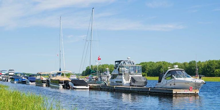
On the Monday morning we awoke to fog; the forecast for the next few days included high winds. Like so many others, we too headed for the mainland to the port at Concarneau, one of France’s most important fishing ports — but also a beautiful historic town with an excellent marina.
The marina is located right beneath the ramparts of the old fortified town, the Ville Close, which can be found on a small island connected to the mainland by a narrow bridge. The first ramparts were built in the 14th century, but the island has been inhabited for at least 1,000 years due to its strategic position in the middle of the harbour.
The walled city is now a tourist destination with restaurants, cafés and crêperies (invented in Brittany apparently) and is also known as the City of Flowers because of all the flowers decorating the old town. There are also many shops and boutiques making it a great place to go for those needing “retail therapy.” It’s also nice to walk around the ramparts, which we enjoyed doing after being aboard the boat for a few days.
Despite being a tourist town, Concarneau is still a busy fishing port with tuna being the most important catch — historically. At the Fishing Museum, the Musée de Pêche, located in the walled city you can go aboard a real fishing trawler; you gain a real appreciation for the working life of those who provide us with delicious seafood. There are also displays and models in the museum that demonstrate how fishing nets are used and what they look like underwater. We found this particularly interesting since we often have to dodge fishing boats at sea; now we have a better understanding of the location of the fishing nets they drag behind them.
As mid-October approached we began planning our return trip north to explore the part of the Brittany coast that we zoomed past on our way south. Paul’s parents and aunt were scheduled to meet us in Brest for a visit after taking the ferry from England to Roscoff on the north coast of France.
Our main obstacle getting back north was going through the Raz de Sein. The Raz is a narrow passage between the cape, and 15 miles of dangerous rocky shoals on the northern route to Brest. Timing this passage for slack water is crucial. Too early and having the tide against you means you get stuck heading into five knots of current. However, if you wait for the current to be in your favour the seas can be extremely rough in the wrong wind conditions. We caught the wind on the nose at 15–20 knots and the seas two metres in the open ocean. Currents converging on the narrow passage meant that the wave energy coming toward us was being compressed — the waves were getting closer together, steeper and much taller. We had a narrow window of perhaps half an hour to make it through with slack water and we arrived right on time — but the waves were still quite impressive. As soon as we got through the seas calmed right down. Amazing!
We arrived at Brest, a major naval port and the main coastal city, in daylight. The next day our guests arrived in time to shop at the delightful Sunday market full of fresh produce, meats, pastries, clothing and jewellery.
Unfortunately, the ability to handle the motion of the sea skipped a generation in Paul’s family. We altered our plan, taking his parents and Aunt Janet on a gentle cruise around the protected Roadstead of Brest, or Rade de Brest, starting at the nearby port of Camaret at the entrance to the Rade.
The village of Camaret used to be an active fishing port with the main catch being tuna and lobster. As the town evolved from a fishing village into a tourist resort, facilities for recreational boats were added and the colourful fishermen’s houses are now shops, cafés and restaurants. Seafood is the specialty; at several waterfront restaurants we enjoyed delicious meals including the traditional and popular “Moules Frites” which are mussels with fried potatoes.
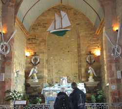
Also of interest right on the breakwalls of the harbour are the Vauban Tower and the fishermen’s and sailors’ Church. The Vauban Tower was completed in 1696, which was once part of the fortifications that protected the town of Camaret and military port of Brest. It’s now a UNESCO World Heritage Site which houses a small museum. At the fishermen’s and sailors’ church, Our Lady of Rocamadour, both local and visiting sailors give thanks for safe passage on the sea. The nave resembles a ship and the altar is decorated and painted like colourful Camaret fishing boats. The steeple of the church was damaged by an English cannonball in one of the many battles that took place on this coast.
Ownership of this region went back and forth between England and France over the centuries. Brittany was at times called Lesser or Little Britain (as opposed to Great Britain), and there are even theories that Brittany was the real location of King Arthur’s kingdom and home of the wizard, Merlin. The Breton people are strongly independent and feel tied to neither. They refer to themselves as Bretons rather than French in many cases and have a distinctly different culture and dialect from other regions of France.
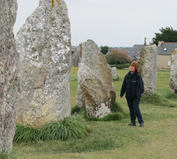
Throughout Brittany there are several sites with ancient standing stones called menhirs. Here at Camaret, within walking distance of the harbour, is a site with 143 menhirs. Originally there were 600. Menhirs are large, upright standing stones, also called megaliths, and there are over 1,200 of them found in various sites in Brittany. Little is known about who created them or why, but they probably relate to seasonal cycles and fertility rites. These standing stones show Brittany’s link to other ancient Celtic sites we visited earlier in Orkney south through the British Isles and also Stonehenge.
There are some wonderful coastal walks along the Crozon Peninsula if you’re based at Camaret. Due to the proximity to the military port of Brest, there are many old fortifications you can investigate along the route. Fort Capucin is placed at a very strategic position at the narrows of Brest, but also controls the entire Bay of Camaret. It looks like an old monastery — of the Capucins Friars perhaps? Actually, it is named for a nearby rock someone thought looked like a monk. The fort was built in 1848 from plans drawn 150 years earlier by the architect Vauban; inside is an underground battery and store carved out of the rock, so this rocky island is now hollow. The French flair for design and fashion even applies to military installations it seems. We sailed past this fort and others on our way back into the Rade de Brest to take the family on a river cruise up the Aulne to the market town of Chateaulin.
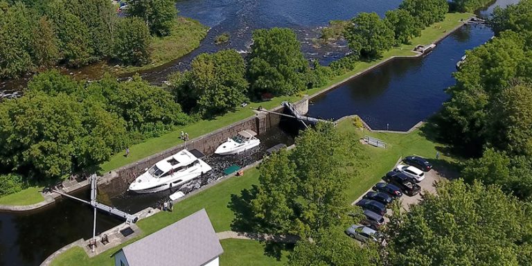
The Aulne River is part of the Canal de Nantes á Brest — a canal that once connected the city of Nantes on the Loire River with Brest on the Atlantic coast, but is now blocked by a dam. The Aulne River is 140 km long, but the farthest from Brest you can travel by boat is to the picturesque market town of Chateaulin, which takes about a day of motoring. There is one lock to go through en route — in October, the off-season, you must call the lockkeeper in advance to warn him that you are coming. We all enjoyed the beautiful, natural scenery along the riverbanks and watching the numerous types of birdlife.
We tied to the town quay in Chateaulin for the night and were treated to another great weekly market the next day where we bought lots of goodies for our last dinner together back in Brest before the family headed back to England.
We continued north up the coast with calm conditions through the Chenal du Four to explore some of the north coast, which for a 30 km stretch has a distinctive and unusual colour. It is called the Côte de Granit Rose, meaning pink granite coast. This special pink rock is quite rare and can be found in only three other places in the world — Ontario (Canada), Corsica and China.
One of our favourite and final stops in Brittany was at the tiny Île de Batz, which lies across a narrow strait from Roscoff on the mainland. At low tide the strait is barely 200 metres wide but almost five times that at highest tides. Tides on the north coast of the Brittany region are big, up to 20 feet, so many of the harbours entirely dry out at low tide. Boats must be able to “take the ground” in such harbours. Our boat, Distant Shores II, built on the south coast of England where tides are also large, has a retractable keel and metal grounding plate built into the bottom of the hull so the boat can dry out safely. Once grounded we put on our rubber mudlarking boots and squelched ashore to wander this quiet little haven.
Île de Batz has a microclimate allowing palm trees, and other plants not natural to this area, to grow. Not only does the microclimate make it possible for exotic vegetation to thrive but it makes Île de Batz an excellent place for agriculture; farming is an important way to earn a living here as you can see from the beautiful crops. There are no cars allowed on Île de Batz but you do see tractors. Many farmers also harvest seaweed, which is used as an ingredient in some cosmetics and medicines.
We found a cosy café on the waterfront, and while enjoying a warming bowl of local fish soup we got into an engrossing conversation with the owner. Time disappeared until we suddenly remembered the rising tide! If it got too high we wouldn’t be able to get back to the boat. We apologized to our host and made a fast exit! The water was visibly sliding in and the level swiftly rose in the harbour. By the time we reached the boat, the water was almost over the tops our boots. Tide and time wait for no man!
We left Île de Batz at high water and made one more stop along the north coast of Brittany at the rare hilltown of Tréguier — our jumping off point for another night crossing of the English Channel. The next morning we arrived back in England, making landfall at The Needles off the Isle of Wight at the entrance to the Solent to store our boat at Northshore Shipyard on Chichester Harbour for the winter.
But we hadn’t seen the last of France…
Photo Captions
Photo 1 – The village of Camaret used to be an active fishing port with the main catch being both tunafish and lobster. As the town evolved from a fishing village into a tourist resort, facilities for recreational boats were added and the colourful fishermen’s houses are now shops, cafés and restaurants.
Photo 2 – This is Ile de Batz. Tides on the north coast of the Brittany region of France are big, up to 20 feet, so many of the harbours dry out at low tide. Boats must be able to “take the ground” in such harbours. Distant Shores II, built on the south coast of England where tides are also large, has a retractable keel and metal grounding plate.
Photo 3 – Throughout Brittany there are several sites with ancient standing stones called menhirs. Here at Camaret, right within walking distance of the harbour, is a site with 143 menhirs. Originally there were 600. Menhirs are large, upright standing stones, also called megaliths, and there are over 1,200 of them found in various sites in Brittany. Little is known about who created them or why, but they probably relate to seasonal cycles and fertility rites. These standing stones show Brittany’s link to the other ancient Celtic sites the Shards visited earlier in Orkney south through the British Isles and Stonehenge.
Photo 4 – Camaret is the fishermen’s and sailors’ church, Our Lady of Rocamadour, where both local and visiting sailors such as Paul and his mother, Cynthia, give thanks for safe passage on the sea. The nave resembles a ship and the altar is decorated and painted like the colourful Camaret fishing boats.
Photos and Story by Sheryl and Paul Shard