BC Tidal Passes: Part 1 – Passes of the Gulf Islands
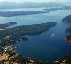
In the first of two articles on the BC Coast’s tidal passes, we survey the passes that link the Strait of Georgia with our most popular cruising ground.
One of the greatest sources of anxiety for new boaters on the BC coast – or boaters new to coastal waters – is the fact that water here moves around – a lot. Understandably, this is a worry I’ve heard from people from the Prairies or eastern Canada who may be used to the relative tranquility of lake boating.
Yet any experienced boater can quickly adapt to cruising on the saltchuck if they keep one tool handy – the Canadian Tide and Current Tables published annually by the Canadian Hydrographic Service (Volume 5: Juan de Fuca Strait and Strait of Georgia covers the Gulf Islands). Trip-planning is easy if you consult the tables to learn when the tide changes, the direction the water is moving and when it is safe to transit a pass. The thought of your vessel being swept by a stream through a pass can be intimidating at first. But cruisers on this coast learn quickly that passes generally lead on to greater things such as sheltered waters and secluded 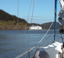 anchorages – and passes generally offer their own rewards as well.
It’s also important to remember that passes can be as changeable as the weather. This is not surprising when you consider how tidal currents are created and influenced by a complex interaction of topography, bathymetry and the twice-daily ebb and flood of the tide. Add fluctuating wind conditions, and a pass that is easily transited on a calm day can represent an entirely different challenge when a strong wind is blowing. For example, on a big flood in a south-easterly gale Porlier Pass is, quite simply, a monster.
In this two-part series we will visit the major tidal passes between the Gulf Islands and Cape Caution. This article examines the passes of the Gulf Islands.
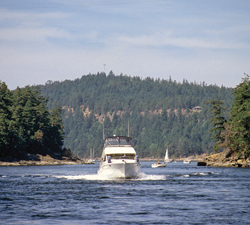
Active Pass
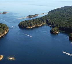
This S-shaped channel is the main pass for commercial and recreational vessels heading in and out of the Gulf Islands, and its transit is complicated by regular arrivals of large, wave-generating car ferries. BC Ferries, often travelling at 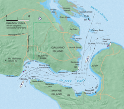 speeds of 10 knots or more in the pass, can kick up a lot of wash and must always be given the right of way. Some pleasure boaters avoid Active Pass because of this traffic, but they are missing a beautiful channel with abundant wildlife, towering bluffs and impressive hydraulics. It is also a forgiving pass in the sense that currents aren’t usually excessive for small boats and there are often ways to work your way through on back eddies if you miss slack water.
Although boaters should never impede a ferry in these restricted waters, staying out of their way is not difficult. You can keep informed on ferry movements by monitoring VHF Channel 16 – they generally announce when they are entering the pass from either direction – or contact Victoria Traffic on Channel 11 to learn about ferries or other large vessels approaching the pass. We generally keep well to the right side of the channel transiting the pass and if a ferry is approaching from behind we give it as much room as is safe. If you linger in the centre of the pass, you could find yourself caught between two ferries approaching from opposite directions – not recommended!
Ideally, you should time your transit of Active Pass for slack water. However, over the years we’ve watched fishing boats and other craft use back eddies to work their way through, and we have employed this method when we have missed slack. When inbound (entering from the Strait of Georgia), we motor between Fairway Bank and the green can buoy at the south end of Gossip Shoals. We stay 200 metres off the buoy, keeping close to the Galiano Island shoreline as we make our way along a back eddy to Mary Anne Point. Once past this point, we are usually able to make our way through the pass, again keeping to the Galiano Island side. However, during strong floods the current at Matthews Point may be too strong, so we sometimes cross over to Lord Point on Mayne Island and work our way close along this shore to the kelp bed east of Helen Point (make sure the channel is clear of approaching ferries and other traffic before you cross over). Then, if traffic permits, we cross back to the Galiano side to exit the pass. If
the current is still too strong, you can wait for slack in Naylor Bay or Miners Bay on Mayne Island.
The western end of the pass, between Helen Point and Collinson Point, is where current is strongest on a flood (up to seven knots on the Mayne Island side) and where you may be tempted to turn up the engine revs to get free. If the water looks rough or the current appears too strong, you can turn around and drift back into Georgeson Bay to wait for the current to ease. Be absolutely sure to stay clear of the reef near Collinson Point marked with a green quick-flashing beacon and do not, on a flood, position yourself in front of it until you are well out of the pass.
From Trincomali Channel, the flood stream juts a pronounced tongue of water into the pass and you can see currents really gain speed just to the east of Helen Point. The stream makes a beeline for the bluffs on the opposite shore where it turns 90 degrees to starboard. When this stream combines with ferry wash, there can be tremendous overfalls and rips in the area west of Matthews Point which are a spectacular sight.
An ebb current is generally less turbulent, although ferry wash will continue to be a problem for small recreational boats throughout the pass. Generally speaking, rips are not as bad during ebbs.
If you’d prefer not to transit Active Pass after a late-evening crossing of the strait or need a spot to wait for slack, you can find anchorage in Whaler Bay just inside the reefs at Cain Point. The public dock farther into the bay may have space, but the water is very shallow near the dock. Miners Bay is another possible overnight location, at anchor or at the government dock, both of which will be bumpy. (See map for detail.)
 Georgeson Passage
We journey south now to two small passes that grant access to the southern Gulf Islands.
Through our early years of boating, Anne and I enjoyed spending Thanksgiving or Christmas at Winter Cove and often used Georgeson Passage to get there. This is a segmented series of passes that begins at the gap between Mayne and Georgeson Islands, where the pass is narrow with depths often less than six feet at low water but about 20 feet at high water. Arrive at high slack or within 30 minutes because there is a very nasty reef on the Mayne Island side and currents in the pass will be swift (about five knots maximum). A small ledge also protrudes about 10 feet out from Georgeson Island and the deepest water is 50 feet north of the island.
Once clear of this gap, proceed to the winding pass between Curlew and Samuel islands. This is a very pretty route where the arbutus and overhanging firs make a fine backdrop for oystercatchers, kingfishers and eagles. In strong floods, especially, there will be sizable whirlpools between the two islands and the worst of the current will be where Curlew and Samuel come closest together near the east end of Curlew. Currents here can often exceed five knots.
The rest of the pass toward the anchorages of Saturna is straightforward with the small whirlpools fading to nothing as  you approach Irish Bay.
Boat Passage
A genuinely hair-raising pass – and one of our favourites – is Boat Passage between Saturna and Samuel islands. During Prohibition, rumrunners used this narrow, reef-strewn notch to dodge government revenue boats patrolling the Strait of Georgia; today it makes a great shortcut out to the strait or south to Cabbage Island.
You can transit this pass from the strait in good weather by dodging the lines of rocks and reefs blocking the way. However in southerly winds, I wouldn’t try it. There is a nasty half-submerged rock on the Samuel Island side that more than a few boats have bumped.
The trick, when approaching from the strait, is to stay closer to the Saturna shore, then angle into the pass as you reach the entrance. Currents here easily reach five knots, more like seven knots in big tides, but at slack the pass is safe with a depth of about 15 feet at high water. Whirlpools form on either side of the pass so if you have missed high-water slack by more than 15 minutes, it’s best to wait this one out.
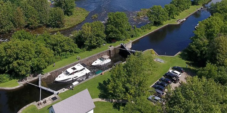
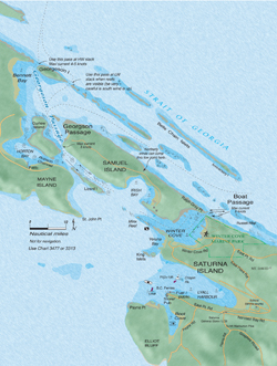
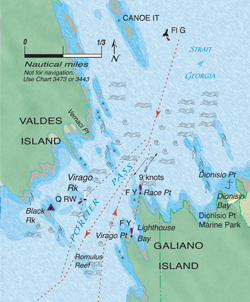 Porlier Pass
The largest “gate” pass – meaning it is short and fast – south of Seymour Narrows, with currents reaching 10 knots, Porlier Pass is potentially the most dangerous of the Gulf Islands passes. Currents here can generate impressive whirlpools and overfalls from Race Point to the reef opposite Dionisio Point, and these are especially hazardous if the current is flowing against strong easterly winds. On big floods, the sight of the water pushing against the rocky west shore of Race Point is impressive. In addition to swift currents, the degree of turbulence here (due to numerous shoals and reefs within the pass) can make the seas in Porlier a force to be reckoned with.
If you miss slack water and the tide is not too large, you can usually work your way through Porlier by staying parallel with the current and steering as close to the centre of the pass as possible. If westbound, we arrive within a quarter- to a half-mile southeast of the green flashing buoy U41 at the north entrance. Lining up this buoy with the light at Race Point allows us a course through the deep water of the pass and out of danger of the rocks off Valdes Island. Once we are about 200 metres off Race Point, we take a middle route through the pass between Virago Rock and Virago Point until we are clear. (There is a Q RW sector light on Virago Rock for night transits.) There can be strong turbulence off Romulus Reef and a northerly set towards the reef extending from Black Rock in floods. It’s essential to maintain your bearings, especially at night, to ensure that you clear these hazards.
Interestingly, the maximum current for the pass at flood (10 knots) is 40 percent stronger than the ebb (seven knots). The stream, in either direction, is a fairly straight and short run, with two major deflections caused by the island topography and numerous reefs.
The main danger when transiting Porlier is being swept onto reefs at the east and west ends of the pass. Boaters sometimes steer too close to Galiano Island and find they are being set onto the reef extending from Dionisio Bay where depths at low water can be just a few feet. The area northeast of this shoal water can be very dangerous in gale conditions and is where some of the Strait of Georgia’s roughest and largest seas can occur.
 Over the years several vessels have sunk in the vicinity of Porlier Pass, including the 190-foot sidewheel steamer Del Norte which sank in 1868 after striking the reefs south of Canoe Islets while trying to back out of the pass. The current (2004) edition of CHS Sailing Directions still notes the location of this wreck.
Another drawback of Porlier Pass is the lack of shelter on the Strait of Georgia side for vessels waiting for slack. Dionisio Bay, at the north end of Galiano Island, provides some shelter in south winds but is quite open to the north. This bay makes a good temporary stop in settled weather, with good holding in sand and mud, and the opportunity to visit the sandy shell beaches of Dionisio Marine Park.
Tugs and barges often use Porlier Pass and you can obtain information on their movements by listening to Channel 11, Victoria Traffic. Tug operators can usually be contacted directly on Channel 16.
Gabriola Passage
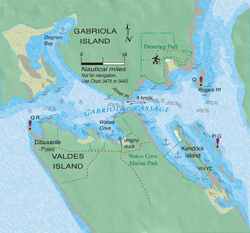 Few passes along the entire BC coast are as straightforward as Gabriola Passage. It’s a yes-no proposition – your boat either has the guts to buck the current or it doesn’t. In sailboats and slower powerboats, there is no way to wiggle through if you arrive late.
In the 1950s, CHS field workers used baby bottles with flashlights inside to measure currents at night in Gabriola Passage. The bottles were cast out from shore with fishing rods; as they were swept through the pass, the workers would take transits on the lights and reel the bottles back to shore. By the 1970s, field workers were experimenting with fixed pods on boats to measure current. Daily tables were introduced for Gabriola Passage in the 1987 edition of the Tide and Current Tables. (Prior to this, predictions for Gabriola were based on Active Pass.)
Gabriola Passage is basically a straight-line stream with the main turbulence occurring with the flood, beginning at the pass and extending to Rogers Reef. Some turbulence can also be expected around the reef near Dibuxante Point. Current in this pass can exceed eight knots on both flood and ebb. The danger at the western end lies near the light beacon off Dibuxante Point – a vessel can be swept onto this reef in either tide direction. You can wait out the tide behind Kendrick Island if bucking a flood or in Wakes Cove if fighting an ebb. The reefs at the south end of Degnen Bay can generate impressive whirlpools and should be given plenty of room.
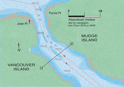 Dodd Narrows
This short pass, with no submerged hazards and a straight-line stream, presents few problems except those created by other boaters. Because it is very narrow – often with fast streams and no room to work back eddies – it is susceptible to wash from fast-moving power boats which, when bucking the current, can trigger large standing waves capable of swamping smaller craft. When the pass is busy, as it often is in summer, slower vessels may want to stand off a short distance to check for oncoming powerboat traffic.
A flood current pushing into Northumberland Channel against a strong summer northwester can result in significant chop for a few miles beyond the pass. Also, there can be strong turbulence on ebbs just east of Joan Point. Maximum currents are in the eight to nine-knot range.
 Nearby lies one of the great temptations in local passes – False Narrows. This is a pretty pass…in a dinghy. We haven’t mustered the courage to go through in our Spencer 35, however. With streams easily reaching four knots, shoal water, kelp and numerous reefs, this is not a safe pass and best left to locals who know it well.
Part 2: Passes North of Desolation Sound
Story by William Kelly
Anne Vipond and William Kelly are authors of the popular Best Anchorages of the Inside Passage distributed in BC by Heritage House.
Photos and maps are courtesy of Ocean Cruise Guides