Marine Mobile and Apps
Convenient, Cool and Low-cost!
By Terri Hodgson
From simple organizational Apps for your smart phone to complete wireless devices and systems, there are a rapidly growing number of products available to the average boater today.
As more boaters integrate their personal wireless devices with their cruising life, the market for marine mobile devices and applications increases. The plus to this trend is that there are so many new and powerful options available to all level of boaters. The minus to this trend is that there are so many options!
Where do you start when trying to either completely outfit your boat or are merely wanting to add a new device in to your existing system? How do you know what is going to be too little, or too much, or be compatible with the electronics in which you have already invested?
 Navigational Apps and GPS
Although the Samsung smartphone devices have overtaken Apple iPhone sales as the leading player, the majority of boaters are still turning to their iPads and laptops to aid in their new navigation set ups and the majority of Apps available on the market today, are intended for use with Apple devices. When you are at the helm it’s important to rely on a navigation set up that is easy for you to operate, but also is also either as simple or as complex as you need it to be. It is always recommended that you keep a set of paper charts on your vessel for reference as a companion to your GPS software or as backup in case of electronic failure.
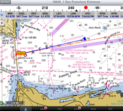
iNavX by GPSNavX (www.inavx.com) was one of the first apps developed for iPhone and iPad to use as a navigational suite. The cost for the app is $49.99 and it includes official and up to date NOAA RNC raster United States waters marine charts for West Coast, Gulf Coast, East Coast, Great Lakes, Alaska, Hawaii, and US Virgin Islands. My family has actually used this App for a few years and while it is best highlighted on an iPad, it is effective also just on an iPhone. We always use the App together with the paper charts, both for planning as well as for having different, simultaneous perspectives of the same area. The convenience of having the App open right at the helm rather than having to duck below to review charts on a larger laptop or other device, makes it easy to transition to using this as your main method of navigation.
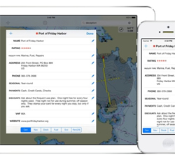 In addition to being able to create routes and waypoints with iNavX you can also use the Navigate To function in conjunction with your instrument readings and arrive at an ETA based on the information provided. Garmin offers a similar App, BlueChart Mobile (www8.garmin.com/apps/), which is a free App and then you buy the charts you want at about $30 each. Although the Garmin functionality is not yet as sophisticated as the iNavX offering it is still a solid choice. The Charts and Tides App from Navimatics (http://www.navimatics.com/) is a good option if you like to keep your active data separately. It is a free download from iTunes for iPad and iPhone.
If you are looking solely for a marine GPS then the new Bad Elf is a smart choice. The small, compact, water-resistant handheld Bad Elf GPS Pro (http://bad-elf.com/products/be-gps-2200) is an Apple-approved accessory that wirelessly connects (via Bluetooth® wireless technology) up to five users of an iPod touch, iPhone or iPad to share real time, direct satellite GPS data for display on digital charts and a wide range of other compatible marine Apps on board via satellite – anywhere in the world.
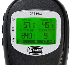 Bad Elf GPS does not rely on cell tower assistance to achieve a lock or to determine position. The Bad Elf unit includes a high performance satellite receiver and antenna that receives data directly from the GPS satellites. Locking on to up to 15 satellites, a Bad Elf unit supplies GPS data up to 10 times a second that can be accurate to within 9 feet (2.5 meters) – allowing users to improve their GPS lock on the water beyond cell phone coverage areas. Bad Elf GPS Pro was the winner of the TechRadar Best GPS Device award at the 2013 Consumer Electronics Show.
Blogging and Social Media Integration while Underway
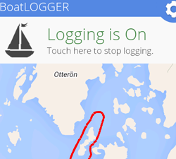
Here’s an App that allows you to log your journey in a virtual way with all sorts of cool features that you won’t find in a hard copy log book. BoatLOGGER (BoatLOGGER.com) is an App for your smartphone that organizes your boating life and serves multiple functions. It offers a Log Book which can be divided into separate trips, years etc. The trips are automatically plotted on the map to show exactly where you’ve been and by clicking on the segment a detailed log book view is shown. This is logged from the free smartphone Apps or from installed GPS loggers. The specifics of the trip are logged in great detail as well. This could be how the weather was and changed during the trip, the sea state, how much the engine was run and specific events such as sail changes, etc. This and other information is logged with a few key presses from a mobile phone. With the phone’s built-in camera you can enhance the log book with a photo at click of a button.
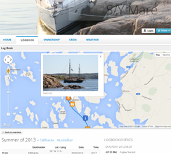 BoatLOGGER also keeps an up to date database about your boat, the intention of which is to help keep you organized. By just entering the brand and the model of your yacht, the site already knows a lot about your boat and you can edit and tweak these details as you like. You can add photos, lists of equipment, manuals, documents and much more. There are even possibilities to track your cost of ownership and running consumptions. All the data about your boat is concentrated in one place. This includes the basic data of the boat, what equipment you have, when you bought it and your manuals and instructions can all be there when you need them.
With the App comes the ability for you to create your boat’s own custom website. Without requiring any technical knowledge you can customize your website and upload any information that you would like to share with your friends and colleagues. You automatically get an address like ‘www.BoatLogger.com/MyBoatName’, but you can also register your own address like ‘www.MyBoatName.com’ if you like. Loggers can also send weather data to the site to track air pressure, temperature, wind speed and other information. Photos taken –i.e. with your mobile phone – can easily be uploaded and even tagged and shown in your log book entry for the journey. Your twitter, Flickr, Blog or Facebook information can also be shown by BoatLogger. If you would like to view a sample website visit www.boatlogger.com/tistle.
 If you are into social media the last component of BoatLOGGER ties all of the other features together with your Twitter, Facebook and other accounts.
BoatLogger also helps you and your friends to stay in contact. They can see how it is for you and can follow your journey or vacation even without you sending post cards. If you use GPS trackers with satellite communication then they can even track you when you are in the middle of the ocean! Your yachting friends and you can share information on the site and in case you have Facebook or Twitter it can be integrated into your yacht site. You can decide who your share which information with and organize your content accordingly. Although this aspect of the App may not be for everyone it is a fun feature and one that will likely become increasingly popular.
One drawback to this App is that it is currently only available for Android, although the iOS version is in development and should be available by Spring 2014. It can be downloaded directly from Google Play. BoatLOGGER offers a free version as well as an available upgraded paid version of the App.
Organization and Utility
Maybe daily Tweets are not your scene and you just want a couple of simple but useful boating Apps.
Two that come to mind are WhatKnot and What’s On My Boat? The sole purpose of What’s On My Boat (www.intelligentmaintenance.com) is to help you list and keep track of all of the stuff you have aboard and where it is located on the boat. To use it, you simply enter the item and then you can add a photo, a location, a category, a list, and a note. The info is stored right on your mobile device so when you go to restock, you have your complete list of needs at your fingertips. When you have stocked and stored everything you need and you are ready to check your rigging and lines, pull up WhatKnot. This handy little App from Columbia Sportswear (www.columbia.com) is the pocket guide to 70 must know knots in six categories. With this App you’ll always have just the right knot at the ready, with clear step-by-step tying instructions to meet any and every outdoor need. What Knot to Do includes illustrated examples of each knot, as well as a full glossary of terms to help make you an expert knotter in no time. Learn to tie the perfect knot, whether for fishing, sailing, backpacking, hunting, building a shelter, lashing up a raft, tying down a load or tying up your llama.
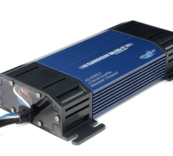 Your day’s cruising is complete; you have organized your vessel and tied all of your knots. To decompress while on board in the evening we suggest you try the Aquatic AV Digital Amplifier With Shockwave Technology (www.aquaticav.com). This cool gadget provides outstanding sound quality in a lightweight, compact and efficient digital amplifier – just 2.5 lbs. and 42.5mm x 218mm x 140mm. Protected against water and dust with an Ingress Protection rating of IP66, you can literally hose down a Shockwave Technology™ amplifier. Shockwave Technology™ incorporates Digital IC’s with specially designed low-noise circuitry to produce high-quality, true sound reproduction from any source. The technology used also reduces unwanted Electromagnetic Interference (EMI), which can cause noise in audio systems. Gold-plated RCA’s and high quality connectors assure the best possible listening experience. Much more efficient than a traditional amp, this digital amplifier produces less heat, which lowers power consumption, reducing strain on batteries and charging systems.
Marine electronic technology changes as fast as everything else computerized these days. Consult with the technical pros at your local marina or chandlery for your best advice on systems, add-ons, installation and any issues with compatibility. Visit our website at www.CanadianYachting.ca anytime for state of the art new marine products and links to dealers and other resources.
Photos
Photo 1: Bad Elf Pro – Uses Bluetooth technology to wirelessly connect up to five users to data in real time.
Photo 2: iNavX – Real-time Navigation on Marine Charts. Position is plotted as Chart scrolls. A velocity vector, Tracks history and a bearing line to the active Waypoint are plotted. Pinch to zoom. Chart can be rotated in North or Course up orientation.
Photo 3: Charts and Tides offers GPS navigation, tides and currents data and active captain integration.
Photo 4: Uses Bluetooth Technology to wirelessly connect up to five users to data in real time.
Photo 5: BoatLOGGER – By using this app on your smartphone your journey is constantly recorded and sent to the website.
Photo 6: An online logbook that tracks your journey and allows you to share it with the people you select.
Photo 7: Aquatic AV Digital Amplifier – High quality, reliable sound that you can hose down if needed.
