Going iPad or Chartplotter, Which is Right for You?
In Going iPad with Marine Navigation we concluded that iPads provide a modern platform for marine navigation. Further, we identified that there are formidable marine navigation apps and numerous products available for protecting and mounting an iPad on your vessel.
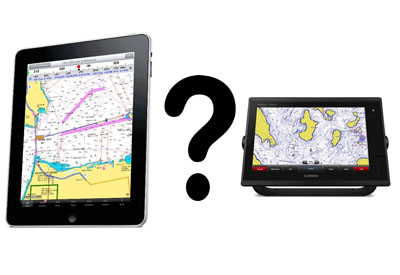
 But how do all these features compare to those of a traditional chartplotter? Let’s consider the functionality of an iPad against the standard features of popular chartplotters like the Garmin
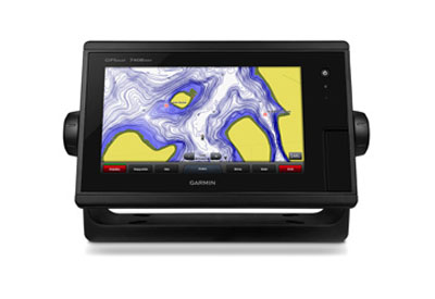
  GPSMAP models (left image) and Lowrance Elite series (right image).
Like iPads that come in various screen sizes it is possible to purchase chartplotters in many sizes, Garmin’s GPSMAP models range from a 5” screen all the way up to a 24” Full HD glass display. The main and obvious difference between iPad screens and chartplotters is visibility.
Chartplotters are designed for high visibility in direct sunlight making navigation easy on those sunny days. iPads, not designed specifically for outdoor use in direct sunlight are well known for being difficult to see. There are screen protectors that can make iPad screens more visible in the sun but they still don’t have the same visibility as the VGA displays of standard chartplotters.
As for mounting options, there are a wide array for both. The main difference is again consideration for the sun. Your chartplotter can go anywhere you can possibly mount it, your iPad can to, but if you plan to use it as your primary means of navigation it is best to consider mounting in a shaded location, or spot that you can easily provide with shade. Chartplotters also come with standard mounting equipment, iPad mounts need to be purchased separately.
Next we need to consider connectivity. It is standard now for chartplotters to have wireless connectivity, allowing for easy access to map downloads and software updates. Chartplotters are also equipped with reliable global positioning system receivers capable of connecting to GPS and GLONASS.
 iPads too have built-in global positioning receivers and can connect to both GPS and GLONASS but as we learned in the initial article of this column connectivity isn’t available in every model and for a reliable connection when out to sea Apple recommends connecting your iPad to an external receiver like a Bad Elf GPS with lighting connector (left image).
As far as standard functions for marine navigation both chartplotters and apps available for your iPad are fully functional for navigation. It is the additional features beyond standard navigation that separate the two.
Chartplotters are designed for your boat and because of that they have features that an app just can’t compare with. One primary feature is the ability to get a chartplotter fishfinder combo, essential for those like me looking for the next best place to toss out a line.
The ability to see under your boat as well as charts provides a significant advantage to mariners. Lowrance has focused a good deal of attention on this ability with sonar technology  like CHIRP sonar, StructureScan and DownScan Imaging.
It might be a surprise to some but there are fishfinder apps for your phone and tablet such as the FishHunter portable fish finder, but you will need to purchase the sonar bobber that sends information wirelessly once deployed in the area you are intending to fish. (right image)

There is also a world of additional marine apps that can be utilized with your phone or tablet like Mercury Marine VesselView that allows you to monitor engine data on your phone. To use the app, you do need to purchase the VesselView Mobile module for $275 (left image)
Some boat builders have also taken the next step, making boats that are predesigned for connectivity with your iPad. Boston Whaler has intelligent, connected boats that when coupled with their app, Whaler Watch, gives you security access to your boat, including the ability toimmobilize the engine, remotely control lighting and air conditioning and monitor temperature, fuel levels, battery and positioning (image below). This app is also available for use with Raymarine chartplotters.

Beyond these just pick up your iPad and type marine into the app store search function and you will be inundated with a wealth of available apps that make the iPad a valuable tool for navigation and numerous other uses.
The biggest downside to using an iPad is the cost of all the additional accessories needed. You will need screen protection, a waterproof/shockproof case and mounting kit and let’s not forget that it is recommended that you also purchase a third-party GPS adapter. You will need to purchase the navigation app of your choice and possibly multiple charts. And if you want to utilize advanced marine apps like VesselView or FishHunter you are again required to get out your wallet, or purse, to purchase the necessary equipment to make the app fully functional.
So, what’s right for you? Both the chartplotter and iPad can provide accurate navigation, and each has additional features that make them unique. The answer really comes down to personal preference, cost and time.
A chartplotter can be purchased and installed with little concern for things like the effects of the elements, and therefore is a great option for those seeking a fast and ready to use option. An iPad requires a little more work, you need to research and purchase the app and maps that are right for you, as well as protection and mounting equipment. The cost can quickly add up and it requires time to research an individually purchase each item. That said if you are willing to invest the time and money it is a powerful tool with an extremely wide range of available features through numerous apps.
Which is right for you? Only you can answer that, just be sure you are well informed of the full range of abilities provided by each of these options before making your purchase!The best way to know which is right for you is research and consideration for your boating activity. Personally, I like to use my chartplotter fishfinder combo to get a good look at the underwater environment around my boat, but for long trips I like the functionality and options provided through navigation apps on my iPad.
Not long ago one of readers asked me why I have chosen to focus on iPads for marine navigation over Android tablets? This question will be the focus of the next installment.
As always, I thank our readers for their valuable input and encourage our audience to continue engaging with us.
Sources:
https://buy.garmin.com/en-CA/CA/cOnTheWater-c519-p1.html
http://www.lowrance.com/en-CA/Products/Elite/
https://bad-elf.com/products/be-gps-1008
http://www.fishhunter.com/home/
https://www.mercurymarine.com/en/ca/gauges-and-controls/gauges-displays/vesselview/
http://www.raymarine.com/view/?id=397
Canadian Yachting recommends that you carry and can use hard copy marine charts in the event of electronic failure.
About the author:
 Owen was born and raised in Midland, Ontario on the shores of Georgian Bay. He has been boating and navigating ever since and has experience as a paddling instructor, rescue boat operator, and a passenger vessel operator for Parks Canada. He is also an avid fisherman. He obtained his Master’s degree from McMaster University and holds SVOP and MedA3 certificates from Transport Canada.