Social Navigation – The Next Dimension for Marine Electronics
In early May, a news story came out that identified the most valuable company in the world. Which company do you think it was? Maybe General Motors…Shell Oil, or IBM? No wait…it must be Microsoft!
Well no, but you’re getting closer. Apple has overtaken Google as the world’s most valuable brand. A new study by global brands agency Millward Brown says Apple is now worth $153-billion, according to the annual BrandZ study of the world’s top 100 brands.
It’s incredible how quickly things can change. What seems like just a few years ago, Apple computers had a small but dedicated following compared to Windows PCs and the iPod was just coming out. But, when people learned how easily iTunes could download music at only $.99 a song to their iPod, millions switched from records and CDs.
Then came the iPhone, the most influential smart phone to hit the market and the one that certainly attracted the most “apps”. Already, the second generation iPad is out and this time, the creative vision of Apple is changing the way people use computers.
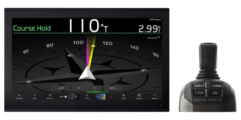
What really shook us up was a statement by the manager of one of Ontario’s biggest yacht repair yards saying that one of their customers planned to remove the marine multifunction display from the helm of their yacht. From now on, they plan to navigate with their iPad.
Come on! Will people really do that?
“I don’t think so,” said Robin Martel, president of Northport Systems and Fugawi who makes desktop, mobile and web-based navigation and mapping software products. We had made an appointment to visit his Toronto offices and to ask Robin for his view of the changing navigation landscape.
“It’s an ‘and’ not an ‘or’ choice.” Martel continued, “I don’t think any sensible person would remove a large-screen, rugged, daylight viewable, marine multi-function display…but I can definitely see them adding new functions.”
We asked him; do people use all the capability of their equipment?
“Increasing capability is not necessarily an increase in usability,” Robin explained, “There is a new focus on the boat and the boater as a person with the technology simply and seamlessly working in the background…the industry is moving in this direction and our goal is seamless plug-and-play connectivity to the boat.”
“The Great Lakes cruising customer already has a variety of devices on board: digital magnetic compass, GPS, depth sounder, wind instrumentation for sailors and engine sensors for the power boaters. Two evolutions have decreased the complexity. The first is the NMEA 2000® standard that facilitates a plug-and-play environment through a standard data network…and that benefits both professionals and do-it-yourselfers,” he said.
“The second is the evolution of interconnected devices that allow us to look at the data on the boat and give us our ability to move data to where you want it, and how you want to display it,” explained Robin.
“Then, we divide the world of information into two areas; we ask ourselves what does the boater need? And then, what added value is there? Examples of added value could include social networking, connecting with friends, gaining tourism information about where you are…information is a two-way street,” he said.
“Now, even if the boat has a variety of sensors from a variety of manufacturers, as long as they are all NMEA 2000 certified products, they can all work together in a plug-and-play environment and connect easily using PC software and mobile software; that is Fugawi’s area.”
Removing a dedicated marine multi-function display is not a good idea, but it could well be an emotional reaction to the level of complexity that frustrates some boat owners. In contrast, their iPad may seem so intuitive to use and so rewarding, that they want to drop other devices.
It may also be based on how that boater uses his devices and what his navigation needs really are. If he is spending his summer cruising a familiar area of Georgian Bay, his navigation needs may be minimal, but his desire to connect with friends and fellow cruisers could be considerable – the main event so to speak.
This is where social navigation has the potential to become a great new dimension to boating!
Imagine getting today’s picture of the barge and dredge that just moved across a channel mouth, the actual fish someone caught, the storm front sweeping in, or a picture of your best cruising friends having a BBQ dinner on board.
While your chart plotter, GPS, radar and other traditional navigation equipment should be a permanent part of your boat, the social navigation opportunities can tell you what to avoid, where to anchor and most importantly, what your friends think of a particular place they have discovered.
This is “user-generated” content and among the big players, Navionics has been quick to embrace the idea of including user-generated content in some of their products.
Fugawi is taking user-generated content to the world of computers and mobile devices. This goes beyond marine navigation products to the wider world of the Internet and even Facebook. The iNav-X chart plotter for iPhone and iPad has a button for one-click sharing of position, waypoint tracks and photographs through Facebook.
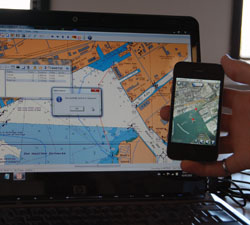
As a demonstration, Robin Martel used a notebook PC that was connected to the Internet and then his iPhone. He went to the chart of Toronto harbour on the notebook, laid in a fast series of waypoints and then in seconds, using Fugawi X-Traverse software, sent the route to his mobile device, the iPhone.
He also had the option of sending information to Facebook to share with friends and in another example, he had a tropical beach photo tagged to a GPS waypoint. Again, it could be shared with friends, or to the greater community of cruisers.
Depending on the bandwidth available to you through a marina or other Internet connection, you can even shoot video, upload and share that via YouTube by sending links to your friends.
Just keep in mind, that there needs to be some background work on your boat to make this work effortlessly.
Not every boat is NMEA 2000, in fact most older boats have the previous standard, NMEA 0183 but even that can be converted to function with new devices.
Robin Martel went on, “Software is now available to display devices such as engine. This software-based display equals a user-friendly way to show data in a very satisfying presentation. A lot of that comes from the modern Windows user interfaced software. Now, we can give digital information an “analog” look with smooth movement and easy to understand graphics.”
You can utilize software information by having a PC or Mac on your boat; you just need the right connections. Northport Systems also distributes Actisense data connectors which are optically isolated, so that the electrical circuit on the PC side of your data connector is completely isolated from the marine electronics side of the connector. This helps to avoid potentially disruptive ground loops and noise.
If you want to connect your computer to an NMEA 0183 data source, use an isolated connector such as the Actisense USG-1 that has USB connectors to a serial NMEA 0183 gateway. If your boat is NMEA 2000, the Actisense NGT-1 is fully firewalled, optically isolated, and NMEA 2000 certified.
Then, you can run ‘Avia Motor’ or ‘Avia Sail’ which are affordable Windows-based software products that can display sophisticated instrumentation and data. These can be used in addition to your helm instrumentation such as in the salon or the engine room.
Avia software receives data from the NMEA 0183 or NMEA 2000 devices and presents the data as crystal-clear analog and digital instruments on your Windows PC, netbook or tablet, designed with a look and feel familiar to all boaters. For the single or multi-engine power boater, Avia Motor supports a wide range of instrumentation and can be configured to display the way you want it. The same is true for Avia Sail and this supports additional instrumentation such as apparent and true wind speed, real-time current, heel angle, and in the Pro version, real-time wind/polar plots.
Sharing any information as you cruise gets you into social navigating. The new technology is user-friendly but as powerful as it personal.
By Andy Adams