Aqua Map: Wind, Waves, and Currents
June 9, 2022
25% for CPS-ECP Members
Aqua Map now includes weather in their app. That sounds so mundane that it may produce an immediate yawn. There are so many dedicated weather apps out there already, what could they possibly offer that’s not already available? Are they seriously going to compete with Windy or PredictWind? It’s a lost cause, one might think, but the genius developers at Aqua Map have produced a unique capability. There are three legs to the weather offering: wind, waves, and ocean currents. So how will Aqua Map differentiate itself from the multitude of weather apps already out there? Here are some details.
Wind. Aqua Map uses NOAA’s HRRR model for wind. It’s a state-of-the-art prediction model by NOAA that’s getting great reviews for accuracy with a resolution of 3 km. It’s updated once an hour with radar inputs every 15 minutes. It predicts for 48 hours so far and only in and near the continental US but within that window, it is more accurate than any other model, especially with the hourly updates with 15-minute radar inputs.
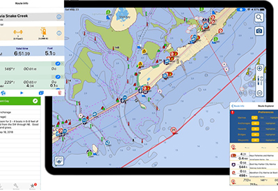
The wind is shown with arrows and a number for speed across the chart which can be easily turned on and off for clarity. It comes with a slider for advancing the prediction across 48 hours – which also advances any tide and current stations in view on the chart, handy for predicting wind against tide conditions at inlets.
With a tap on any chart location, a pop-up will appear with the full weather conditions for that point and a sidebar with access to a seven-day general prediction. Also on the sidebar is a link to the text NOAA 5-day coastal marine prediction, the same forecast given over VHF but in text form to be read at your leisure. The tap on the chart knows which NOAA marine forecast to load, no searching.
Waves. Another selectable display is wave direction and wave height. This won’t be from HRRR but from theWavewatch III model from NOAA. The 48-hour slider is used to predict waves, tides, and tidal currents too – handy at an inlet to see if you have tide against wind.
Ocean Currents. A third selectable display is ocean currents, an innovated step by Aqua Map, most notably the Gulf Stream. The predictions come from the Global Real-Time Ocean Forecast System from NOAA. It shows current direction, speed, and even eddies. It comes with a 48-hour prediction slider. I think it will be a favorite of those going to the Bahamas.
The three displays are color-coded for intensity with red being the most intense. The size and density of the display icons are selectable with a slider in the Settings menu as to whether you want to see numbers (for speed) for each icon on the chart or just a color code along with the directional icons matching a color-coded legend on the side of the display. All three displays cover the entire world but the wind display for the US coastal waters uses NOAA’s HRRR high-accuracy model.
So, what dedicated weather apps have the same capability? PredictWind offers HRRR but as far as I can tell from their documentation, it’s only updated every six hours and does not display speed except at a single point with a tap. Windy does not offer HRRR at all
CPS-ECP members will receive a 25% discount when they download the app of the navigational waters of their preference. To get your 25% discount when placing your online order please enter the discount codes listed in the member’s site (log-in required).
Aqua Maps is proud co-sponsor of Volunteer of the Year Award and Officer of the Year Awards
Member Testimonials:
“We are using Aqua Maps as our main source of navigation as we transit through the ICW. The new feature of winds, waves and currents have been invaluable.”
“This is great. I’ve heard much about Aqua Map and was debating not knowing how it would be for cruising around the Atlantic Provinces. After reviewing the video on Aqua Map’s user info, being a CPS member and applying the 25% discount there is no hesitation now.”
Learn more: