Cruising the North Channel
Story and photos by Maurice Marwood
Introduction
During the summer of 2016, my wife and I cruised through the North Channel in Lake Huron on our Mainship 30 Classic Pilot. This summary of our cruise is intended to help others plan a similar cruise. There is much written about the North Channel so there is no need to describe the region, although we encourage you to do some research. The North Channel has been described by many as one of the best cruising grounds in the world.
Hopefully, this summary of our personal experience may help make your cruise more enjoyable. There are many ways to make the trip depending on several factors that must be considered, such as time available, type of vessel, speed of travel, the route traveled, places visited, ease of anchoring, etc. The observations made below are based on our actual experiences.
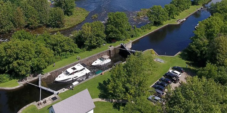
 Route Travelled
This chart illustrates our route [include picture of chart]. We went up the western side of the Bruce Peninsula to Killarney, through the North Channel from east-to-west, then down the U.S. side of Lake Huron.
Locations stopped in Canada include (20 locations):
• Puce River Marina
• Sarnia Yacht Club
• Grand Bend Marina
• Bayfield Marina
• Kincardine Marina
• Port Elgin Marina
• TobermoryHarbour
• Killarney – Sportsman’s Inn
• Covered Portage Cove – Anchored
• Snug Harbour – Anchored
• The Pool, Baie Fine – Anchored
• Little Current – Town Dock
• Logan Bay – Anchored
• Benjamin Islands – Anchored
• Eagle Island – Anchored
• Spanish Marina
• North Channel Yacht Club
• Blind River Marina
• Thessalon Marina
• Hilton Beach Marina
Locations stopped in the U.S. (11 locations):
• Drummond Island Yacht Haven
• Harbour Island – Anchored
• De Tour Village Marina
• Roger’s City Marina
• Alpena- Thunder Bay Shores Marina
• Port Austin State Dock
• Port Sanilac Harbour Commission
• Lexington State Dock
• St. Clair Harbour Marina
• Algonac Harbour Club
• Jefferson Beach Marina
 Essential Charts
It is assumed that all boaters cruising to the North Channel have a GPS Chartplotter on their vessel with the detailed maps installed to aid in navigation. In addition, it is strongly recommended to carry the following paper charts:
Lakeland Boating’s Lake Huron Ports O’ Call — This chart book includes descriptions of the main ports on both the Canadian and U.S. sides of Lake Huron.
The Ports Book – Cruising the North Channel — This chart book describes the Canadian ports in both Georgian Bay and the North Channel. Unfortunately, it does not include U.S. ports on Lake Huron, so you’ll also need the book above if you plan to touch the U.S. coast.
Richardson’s Chartbook and Cruising Guide for Lake Huron, including Georgian Bay and the North Channel — This chart book is essential because the charts are reproduced from the latest available government charts, and most appear at the same scale as the original. The charts are formatted into a convenient 12” x 18” format and bound for ease of use. These charts contain the Georgian Bay small craft routes with a red line that is easy to follow.
I would also strongly recommend a large scale government chart of the entire Lake Huron that includes all of the Georgian Bay and the North Channel on one chart. This will give an overall perspective that the other chart books do not provide.
Navigation
There is a perception among many boaters that the North Channel is difficult and risky to navigate. Based on our personal experience, I would categorically disagree with that perception. We found the tricky areas well marked with buoys and the chart books gave excellence guidance to minimize the risk. I would encourage you to cruise the tricky areas because they are the most scenic and the most interesting. All it takes is a little common sense to plan ahead, review the charts, and stay alert. Travel only in the daytime when visibility is good. This practice is no different than what is required for safe boating on any unfamiliar body of water.
Depending solely on your Chartplotter is a big mistake – invest in good charts, study the route you intend to follow, and read the information provided. If you follow that advice you should have no problems with navigation. If you don’t know how to read a chart – learn. Do not let the misconception about hazardous waters and dangerous navigation hold you back.
 Travel Statistics
• Duration of trip – 51 days
• Days on the anchor – 11
• Days of no travel – 18
• Distance travelled (from GPS odometer) – 890 nautical miles = 1,024 statute miles
• Hours travelling – 124 hours (engine hour-meter reading)
• Average speed – 8.25 statute miles per hour = 7.2 nautical miles per hour
• Fuel burned – 1,460 litres = 321 Imperial gallons = 386 U.S. Gallons
• Average fuel consumption – 11.8 litres per hour = 3.1 Imperial gallons per hour
• Average fuel cost – $1,478 = $1.01 per litre
• Average mooring cost – $1,837 = $1.49 per foot of length
• Some meals purchased – 38 days (13 days ate entirely on board)
• Cost of purchased meals – $1,948 = $51.24 average per day for 38 days (excluding groceries)
Cost of the Cruise
• Fuel – $1,478
• Mooring – $1,837
• Meals – $1,948 (groceries excluded)
• Miscellaneous (pump outs, etc.) ~ $200
• Total ~ $5,500; or ~ $108 per day
Weather
Always check the weather using a VHF radio and two or three weather apps whenever you can connect to a Wi-Fi hub. Most of the marinas have Wi-Fi; however, the connections are typically very poor or non-existent. The best connections we found were in the local libraries of the towns visited, but often they were open connections with no security. Cellular data connections may serve as another option. The best option is a VPN (Virtual Private Network*).
We experienced excellent weather with the days in the high 20s and cooling off at night to about 18C to 20C. We received a ‘heat alert’ when the temperature was predicted to go to 27C! There was almost no need for air conditioning. We were only held down one day due to bad weather. Waves were usually about ½ metre or less.

Observations
Although we visited 31 different locations, there are many others that we did not visit. That includes villages such a Kagawong, Manitowaning, Gore Bay, Meldrum Bay, and Bruce Mines, as well as many more excellent secluded and protected anchoring spots. And many of the spots visited could be visited a second time for more exploration.
Tune your VHF to channel 71 at 9:00am each morning to get some news, weather, and communications with other boaters. It’s also a good way to get help if needed.
To properly appreciate the North Channel one must anchor. If you don’t want or like to anchor – don’t go. I wish we had done more anchoring, and now that we have seen many towns and villages, we will do more anchoring next time. The water temperature was about 20C, but we swam every day at anchor in clear water.
Given a choice, I would recommend traveling the North Channel from west-to-east to take advantage of the winds that predominantly blow from the west. This would be especially recommended with a sailboat, and it’s always more comfortable in a powerboat with the wind and waves on the stern.
A significant reduction in cost would be realized with more anchoring and eating more meals on the boat. However, we believe that exploring the local eating establishments significantly adds to the enjoyment of cruising.
Typically, we would depart about mid-morning and travel for about three to four hours (30 – 40 miles). That allowed time in the afternoons and evenings for exploring and relaxing. Several times we chose to stay put for two or more days to relax, take a land-break, and do more exploring. It is important to allow sufficient time to see and experience what the region has to offer.
 Conclusion
The North Channel should be a high-priority destination for all cruisers and is highly recommended. We hope to do it again, travelling from the west-to-east, anchoring more, and stopping at different locations. There is plenty to see and do to justify two or more extended visits.
* From Wikipedia:
A virtual private network (VPN) is a virtualized extension of a private network across a public network, such as the Internet. It enables users to send and receive data across shared or public networks as if their computing devices were directly connected to the private network. Applications running across the VPN may therefore benefit from the functionality, security, and management of the private