Clayoquot Sound
Clayoquot Sound
Clayoquot is one of the major sounds on Vancouver Island’s wild West Coast, and a haven for cruisers in search of peaceful, remote harbours.
Story & Photos by Shawn and Corinne Severn
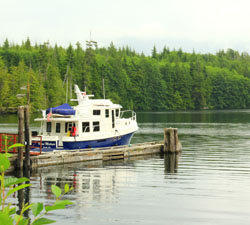
At the dock in Victoria, we were filled with the anticipation of a new adventure. We were fully provisioned and had carefully reviewed the weather window, consulted the charts and checked all of the vital equipment on Ocean Mistress, our American Tug 41. Like children on Christmas Eve, we pretended to sleep before we departed for our trip. We only had time for a short vacation and desired a place away from the crowds. The west coast of Vancouver Island was our objective.
Our destination, Clayoquot Sound, was an important area during the early exploration of British Columbia’s west coast. It was used as stop for repairs and provisioning by explorers before they cruised down the Strait of Juan de Fuca to Victoria. It was also a place of terrible violence where the American ship Tonquin was attacked and its cargo plundered during an 1855 battle that left the scalps of the victims displayed on shore.
More recently, it played a vital role in the development of modern environmental and cultural awareness. In the 1980s and ‘90’s, the residents of Clayoquot Sound, Tia-o-qui-aht and Ahousaht First Nation Bands, and environmental groups (Greenpeace and Friends of Clayoquot Sound) came together to preserve large natural areas from excessive clear-cut logging. Their campaigns fundamentally changed the way we view and value the land and water on the West Coast.
Today, Clayoquot Sound is home to several First Nations communities, provides a home base for many commercial and recreational fishermen, includes both national and provincial Parks (Pacific Rim National Park and Strathcona Provincial Park,) and offers wildlife viewing opportunities and remote cruising destinations.
Remote Anchorages
Clayoquot Sound offers some of the nicest remote anchorages in the Northwest. We spent the majority of our time in remote areas of the sound, a real paradise for cruisers seeking quiet harbours and majestic scenery.
On our first night in Clayoquot, we anchored in Quait Bay. In our logbook, we refer to this spot as “Quaint Bay.” The entrance is narrow and a little hard to spot, and boaters need to watch for a number of small islands and hazards on their approach to the bay. The narrow entrance and good holding make it an excellent all-weather anchorage. It can accommodate many anchored boats, but we found ourselves alone.
There is a former fishing resort on shore. We took our dinghy over to see if there was anyone around and met the handyman, Hans. He told us the resort was closed in 2008 and sold to the owners of the fishing resort in Bedwell Sound.
The next day, we followed the shore along Meares Island heading for Tranquil Inlet. This route passes a favourite spot of the wildlife tour boats: they bring people from Tofino to view bears along the shore. We watched a mother bear and her cubs foraging along the shore as we passed – they seemed unconcerned by the boats.
 Tranquilito Cove, described in the cruising guide Exploring Vancouver Island’s West Coast by Don Douglass and Réanne Hemingway-Douglass, was our next stop. This cove near the northeast head of Tranquil Inlet is very cozy, with room for two boats. It is well protected from the breeze that blows up the inlet, and our ideal of a secluded and remote anchorage. It has a narrow entrance that can be hard to see on a foggy day. Inside, a set of fish pens that were not in use occupied one corner. The mud bottom made easy work of anchoring, and the only drawback was a lack of shoreline for walking our dog Prince.
The following morning, we took our dinghy to the head of Tranquil Inlet to explore the gravel beach that was accessible at low tide. We made several passes before landing to make sure we would not surprise any of the local bears. Once ashore, we found a stream that came down and walked up it a short distance, but the thick mud made walking very difficult. Prince sank to his belly in the stream and the thick, sticky mud, enjoying every minute of running in and out of the stream. Little did he know it would be the dreaded bath for him when we returned to the boat!
Keep It Loose
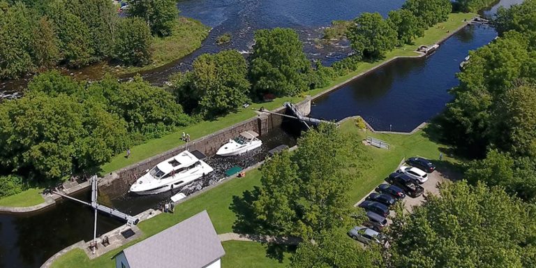
After breakfast and cleanup, we headed out with no particular destination in mind. We were on the lookout for an inactive logging road that would provide us all with a good opportunity for a longer walk. At the south end of Tranquil Inlet we spotted a road at Rankin Cove. According to the cruising guides, this has been a very busy hub for logging, but when we entered, we found no active logging. We docked Ocean Mistress on the small wharf and went to explore. Logging operations had likely been shut down recently because the roads had no new shrubs growing on them yet. There were still some sheds, fueling equipment and pickup trucks, but all other equipment had been removed.
Our stop at Rankin Cove demonstrated the advantage of cruising with a flexible itinerary. While the cruising guides are excellent resources, they may not have the most up-to-date information. We originally had no plans to stop here but it turned out to be a good overnight spot for us, where we could enjoy a walk on a calm day.
Matilda Inlet on Flores Island was our next destination. Well down the inlet there is a beautiful bay. It is shallow in the south end, but the north end has enough water for most cruising boats. The bay is subject to a moderate breeze in the afternoon but is usually calm at night.
There are lots of places here to explore by dinghy. On the west shore, there is a natural spring of lukewarm water and a man-made cement bath. From the bath, a trail leads to the white-sand beach on the southern side of Flores Island, but we found the trail to be heavily overgrown and extremely muddy. We tried to walk it, but after Shawn did a face-plant in the mud we considered other options.
We decided to take our very capable dinghy around the peninsula to the sand beach. We found the foreshore off the beach to be very shallow: a quarter-mile from shore, the depth was only four feet. At low or mid-tide, the shore is a beachcomber’s paradise. Near the east end of the beach, a rocky outcrop held some tide pools filled with mussels and anemones.
Also worth exploring in Matilda Inlet are the communities of Marktosis and Ahousat. Marktosis is the First Nations community on the east shore. The name is derived from the word meaning “coffin” or the verb “to bury” but we found it be a thriving place. There were lots of children and youths playing on the docks. The daring ones were jumping off the pier while the rest of the group hooted and hollered. However, we decided against taking Prince ashore because the local dogs run free in packs.
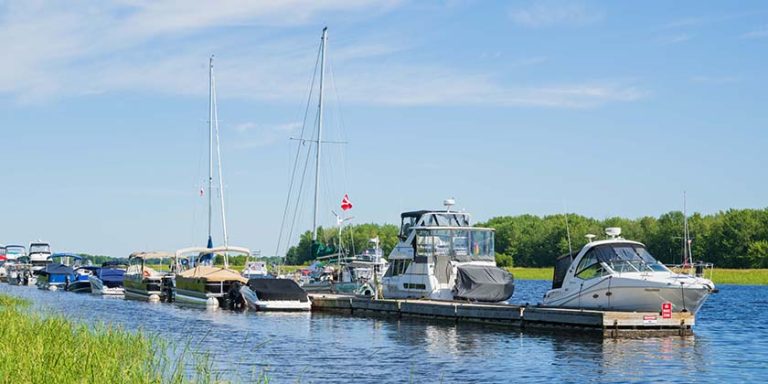
Ahousat is on the west shore of the inlet but is not as large a community now as it may have been in the past. The general store here carries a wide variety of dry goods, fresh food and general hardware; it is also the local hub for mail service. We met several cruising folks who were staying at the dock – they told us the price for moorage was very reasonable but the wash created by small boats zipping by at all hours was very unpleasant.
On Our Own
The following day, we travelled a short distance up Millar Channel to Hayden Passage, then on to Bacchante Bay at the head of Shelter Inlet. Surrounded by steep cliffs, the bay is large enough to accommodate a dozen anchored boats, but again ours was the only boat. Although some cruising guides describe this bay as typically calm, we experienced afternoon breezes of 10 to 15 knots. But the bottom offers very good holding and our boat danced comfortably around the anchor most of the afternoon.
At high tide, we took our dinghy up Watta Creek. We easily floated over a few fallen trees that blocked the entrance at low tide. However, farther up the channel a series of deadfalls made the creek impassable for our dinghy. It would take kayaks and a little wet portaging to get around these trees.
The next day we anchored in Young Bay, a well-protected spot with room for three or four boats. Two small islands lie at the entrance to the bay, with underwater outcrops that reach out to grab the unwary boater. We anchored behind one of the islands.
 Shortly after we arrived, a commercial fishboat came in to retrieve a longline. The floats that we had assumed marked crab pots were actually markers on the ends of the line. We had to raise our anchor to untangle it from the line. This wasn’t difficult but we felt that the fisherman was a little disgruntled with us for messing up his set.
Young Bay was the location a rendering plant that was built to serve the once-thriving pilchard fishery. We explored the old bricks and footings that once supported the plant and found some of the former iron works. As we enjoyed the quiet solitude, it was hard to believe this portion of the coast was heavily populated from the 1920s to the 1940s.
Our next destination was Steamer Cove. It was a little more open than our previous anchorages and the water was quite deep. But we found pretty good protection once we tucked back into the innermost corner of the cove.
We landed our dinghy by the old logging site and found it quite overgrown. Nature is resilient in wet coastal areas and it doesn’t take many years for new growth to emerge and consume the remnants of human activities. On the other side of the bay there was a grassy shore that was wet and muddy, with the remains of many shucked oysters. Under some trees, we found an area where the grass had been flattened – it looked like a fine resting spot for a local bear.
We planned to head to Tofino for our last night but couldn’t find suitable moorage. A rendezvous and a large number of sport fishermen were using the docks for their overnight headquarters. The weather was calm so we decided to continue south to Ucluelet. Despite our late arrival, the friendly and helpful harbour master made space for us on the dock.
Our next overnight destination would typically be Bamfield, where we would prepare to head back to Victoria. Usually, we give ourselves about three days to watch and wait for the right weather window to transit the Strait of Juan de Fuca. But the weather was in its mild summer pattern, so we opted to spend a few days among the Pinkerton Islands in Barkley Sound. Soon enough we would return to the hustle and bustle of our working lives!
 Shawn and Corinne Severn live and work on their American Tug 41, Ocean Mistress. They can be found cruising anywhere from Olympia, Washington to Juneau, Alaska during the summer. In the winter they retreat to the warmer climes of Las Vegas. They have actively cruised on the West Coast for over 25 years.
Getting to Clayoquot
Stretching nearly 100 miles from the Salish Sea to the Pacific Ocean, the Strait of Juan de Fuca represents a significant barrier to the west coast of Vancouver Island for many boaters. Several good cruising guides discuss how to make the trip. Two that we prefer are Voyages to Windward by Elsie Hulsizer and Cruising Guide to the West Coast of Vancouver Island by Don Watmough.
We have cruised to the West Coast numerous times and we have used the same strategy every time. We always stop at Victoria, where we provision in the grocery stores and enjoy a few days in this wonderful historic city. This allows us to complete another day or so of work while watching for the appropriate weather window. While in Victoria, we watch for four conditions: a long outgoing (ebbing) tide, good visibility with minimal fog, low to moderate swell, and minimal inflow (westerly) wind.
We planned the trip described in this article early enough in the year so we could select the most favourable outgoing tide that started early in the morning and lasted much of the day. This reduced the duration of our first leg by about an hour. However, the risk is that you may encounter a larger swell and some wind waves if wind and swell are contrary to the tidal flow. We watch for wind speeds less than 15 knots, which is pretty common in July and August. In general, winds are light in early morning and tend to rise to about 15 knots in the late afternoon. Leaving around 0600 or earlier minimizes the exposure to the stronger winds of late afternoon. We usually expect a little rolling on the way out – so seasickness aids can be helpful. And keep in mind that radar is essential for departures in the dark of morning.
We prefer to travel directly to Bamfield in Barkley Sound, about 90 miles from Victoria, on our first day. At eight to nine knots, it usually takes us between 11 and 14 hours. From Bamfield, we try to get to Clayoquot Sound by mid-afternoon on our second day. Many boaters like to stop in Tofino but its harbour has strong currents and favours smaller fishing boats so we usually pass it by. There are many reasonable destinations for your first evening in Clayoquot Sound.
Our Itinerary
Victoria, Bamfield, Quait Bay, Tranquil Inlet, Rankin Cove, Matilda Inlet, Bacchante Bay, Young Bay, Steamer Cove, Ucluelet, Barkley Sound, Bamfield, Victoria
Photos
Photo 1: Rankin Cove proved to be a great overnight spot, with a logging road to stretch our legs.
Photo 2: Tranquil Inlet is pure West Coast: rugged forested shorelines draped with low-lying mist.
Photo 3: Ahousat is one of two communities on Matilda Inlet. Its general store carries fresh food, dry goods and hardware.
Photo 4: Author Shawn Severn…and the catch of the day.
Photo 5: Shawn and Corinne Severn.