Sidney Spit, BC
A pearl among Gulf Islands parks, this sandy haven is ideal for hiking, beachcombing, birding, fishing…or just hanging.
Sidney Spit is a park of superlatives. With the best sandy shores, the best sunsets, the best crabbing and some of the best hiking in the Gulf Islands, it’s no wonder it’s a hit with just about all who visit – for a few hours, a day or a week.
The park occupies 178 hectares at the north end of Sidney Island, among the most geologically diverse of the Gulf Islands. The island is composed almost entirely of quaternary drift deposits – unconsolidated sands and gravels deposited by glaciers about 10,000 years ago. They predispose its shoreline to erosion, not to mention the most extensive beaches and the most restless sand.
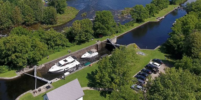
The park, part of Parks Canada’s Gulf Islands National Park Reserve, is shaped like a lobster claw, with Sidney and Hook Spits as the pincers. Between them, the anchorage is somewhat protected from most directions, except at high tide, when all that’s left of two-kilometre Sidney Spit are pilings in the water. (See sidebar “Spit or No Spit”) At the head of the anchorage, the lagoon that seems to be slowly changing into a salt marsh fronts the park’s expansive campground and supports a plethora of bird and sea life.
 Sidney Spit, of course, is the park’s most notable attraction. The skinny sand strip stretches northwest toward the tiny navigational light at its end. Walking to the light will take longer than you expect: exploring the low-tide activity on both sides of the bar, navigating around the jumble of driftwood, and wading in the inviting but frigid waters can add many minutes to the trek, especially if you’re accompanied by children or dogs. And remember that the rising tide usually cuts off the end of the spit from the main park and dock area.
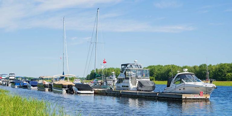
The park offers 17 mooring buoys, more than 300’ of dock space, a dinghy dock, a seasonal ferry from Sidney on Vancouver Island, a campground, and some of the most enjoyable hiking in the Gulf Islands.
Getting There
The spit is only 2.5 miles across Sidney Channel from the town of Sidney, at the southern end of the Gulf Islands archipelago. Charts show extensive areas of shallow water around the anchorage and mooring field, although there is plenty of depth inside. Large-scale Chart 3479 is your best guide, but bear in mind that ever-shifting sands mean charts may not be entirely reliable.
 The easiest approaches to the anchorage and mooring buoys are parallel to the spit from its northwest tip, and from the west at the end of the mooring field. If approaching from the northwest, give the tip of the spit a lot of respect – strong currents here can tug you toward the sands if you’re not careful. Steer parallel to the beach, down the avenue of mooring buoys.
You can also enter from Sidney Channel on the route generally used by the Sidney ferry. Steer just north of the last of the mooring buoys; you may also find one or two private buoys that mark this entrance. If in doubt, follow the ferry, and consider arriving or leaving on a flood tide, when rising water will float you free if you discover your own private sandbar.
While the anchorage may seem like a haven upon arrival, only plan on overnighting when fairly common westerlies or northwesterlies are not forecast. Many a boater, including ourselves, has spent a very unpleasant night surging against the docks, plunging on the buoys, or dragging anchor in the soft sandy bottom. If you plan on dropping the hook, we recommend the west side off Hook Spit, which offers more protection from swells and westerlies. The anchorage is also open to waves from passing marine traffic like crab boats, navy vessels and the Anacortes ferry, all of which are magnified at high tide when the spit and the protection it affords disappear. But in settled conditions there is no better place on earth or water.
History
 Originally known as Sallas, the island was a year-round haven for the Coast Salish, who gathered shellfish and plants here, and fished on its northwest side for millennia. It was also one of the earliest places discovered by more recent arrivals, settlers and miners, en route to the Fraser River from Fort Victoria during the 1858 gold rush. No surprise then, that in 1859 Capt. George Henry Richards surveyed the area and renamed it Sidney in order to make it more attractive to potential landowners. A year later the Hudson Bay Company offered the island for sale at 6 shillings an acre.
Between 1906 and 1915, a brickworks that employed 70 men operated on land now within the park and signs of it are common: broken bricks are visible along the trail and on the shores of the lagoon. Some logging of old-growth Douglas fir was also carried out during the two world wars.
In 1910 a group of Victoria businessmen bought the island as a hunting preserve and introduced many exotic species, including peacocks and guinea hens, while another species introduced on nearby James Island soon swam ashore at Sidney to complicate the fauna mix – the fallow deer.
In 1981, when Sidney Spit was established as a provincial marine park, the remaining two-thirds of the island, 712 hectares, was purchased and subdivided into 24 lots by Sallas Forest Strata Corporation. In May 2003, the park became part of the Gulf Islands National Parks Reserve.
Attractions and Diversions
Birders will enjoy walking to the lagoon and the old wharf to see large numbers of shorebirds during spring and fall migrations. Located on the edge of the Pacific flyway, Sidney Island supports black oystercatchers, marbled murrelets and great blue herons, as well as flocks of Pacific brant, Pacific mew gulls and many migrating shorebirds. Purple martins have also made a comeback and can be seen in nesting boxes on both docks.
Some of the more sensitive ecosystems in the park are closed as part of a special preservation zone. No longer can you take your dinghy or kayak into the lagoon or explore the small island there. The small dock nearby is also off-limits, as is Hook Spit, except for the narrow strip along its outer edge. Sidney Spit strollers are asked to walk on its sandy edges only, to protect vegetated areas.
“The area receives added protection because of its salt water marshes and fragile dune ecosystems. It is home to several species at risk, including nighthawks,” explains Laura Judson of Parks Canada.
Campers will find 30 soft, grassy sites on which to pitch their tents, with toilets, water, picnic tables, covered picnic shelter and privacy. Because the campground is a kilometre from the wharf, they’ll also appreciate the wheelbarrows available near the docks. Due to its high sodium content, the park’s drinking water is not very palatable and not recommended for those with kidney or heart concerns. Many campers prefer to bring their own water for drinking and use the park water for washing.
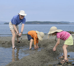
Families can enjoy lounging on the extensive beaches while the children build driftwood shelters, try to catch a squirting clam or geoduck, check out critters in the tide pools, splash in shallow water, or create sand marvels.
For hikers, the park offers endless kilometres of beach walking and forest trails under a canopy of cedar, hemlock, fir and maple, made more enjoyable and informative by several interesting signs on the loop trail. Swimmers will find warmish water on an incoming tide on the north shore of the spit, as well as off the beach facing the anchorage.
Everyone will enjoy the expansive picnic areas with tables, toilets and views from the headland. Even if indolent skippers and crew don’t leave their vessels, they can still enjoy watching the passing scene, dropping a crab trap, or just savouring the sunsets and the scenery.
Spit or no Spit
The pilings that bristle out of Sidney Spit, or sometimes out of the sea at high tide, were placed there when BC Parks owned the site in an effort to stabilize and preserve the fragile spit. When the Gulf Islands National Park Reserve was established, however, its mandate was not to take any further preservation action, according to Laura Judson of Parks Canada.
“The only stabilization projects we do in the park are temporary in cases where a sensitive resource such as an endangered species or cultural resource needs protection, so we do not have plans to stabilize the spit. A fair amount of material is actively transported to the spit through ocean currents, so it is unlikely that it would be significantly reduced in size over the next century, though it may change somewhat.”
Opinion on that timeline is divided, however. Many long-time cruisers like Bill Wolferstan (Cruising Guide to British Columbia, Vol. 1: Gulf Islands) believe that change may come more rapidly. We are also of the impression that Sidney Spit is disappearing, and that its shifting sands make the anchorage even shallower than originally charted. And is it just our imagination – or is it really getting harder to find enough water for our scant three-foot keel at low tide near the head of the public dock?
Details
Sidney Spit Ferry: www.alpinegroup.ca (click on the ferry link)
Park Information: www.pc.gc.ca
Charts: 3479, 3441, 3313
Parks Canada removes the docks at Sidney Spit for the winter, from October 1 to May 14. If you visit between November 1 and February 28, be aware that a portion of the park is closed annually to allow for Coast Salish hunting of fallow deer. Stick to the mooring buoys, the picnic sites adjacent the dock area and the spit itself, and use caution during these months.
Photo Captions
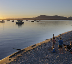
Photo 1 – Sandy Sidney Spit is among the Gulf Island’s best destinations for hiking, beachcombing, crabbing, and enjoying superb summer sunsets. Kevin Oke Photography
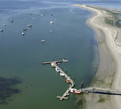
Photo 2 – Part of Parks Canada’s Gulf Islands National Park Reserve, Sidney Spit offers visiting cruisers 300’ of dock space, 17 mooring buoys and extensive anchorage, as well as lots to do ashore. Kevin Oke Photography
Photo 3 – The beach and tide pools on east side of the spit are great for exploring…or just mucking about. Kevin Oke Photography
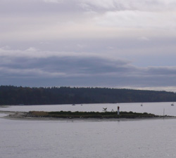
Photo 4 – The spit extends two kilometres from the main part of the park. It’s a great walk but be aware that high tides now cut off the end of the spit from the dock. Cherie Thiessen Photo
By Cherie Thiessen